Dromahair
| Dromahair Droim Dhá Thiar Dromahair |
||
|---|---|---|
|
|
||
| Coordinates | 54 ° 14 ′ N , 8 ° 18 ′ W | |
| Basic data | ||
| Country | Ireland | |
| Connacht | ||
| county | Leitrim | |
| ISO 3166-2 | IE-LM | |
| height | 51 m | |
| Residents | 748 (2011) | |
| Telephone code | +353 / 71 | |
|
Main street, dromahair
|
||
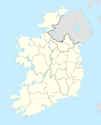
Dromahair ( Irish Droim Dhá Thiar ) is a village in County Leitrim in the Republic of Ireland . There are two possible meanings of the name in Irish : The first, Droim Áth Thiar , means "hill at the western ford" and refers to the location on the River Bonet. The second, Droim dhá Eithiar , means "hill of the two demons". The place has 748 inhabitants (as of 2011).
Dromahair sits on the banks of the River Bonet near the east bank of Lough Gill . It used to be the seat of the O'Rourkes, kings of Brefnie . In the village there are still the remains of a castle and a little outside the ruins of the Creevelea monastery and Parke's Castle . Since the 1990s, the place was badly affected by the construction boom in Ireland; several hundred houses have been built, a number of which are empty. In Dromahair there are a few shops, a pharmacy, a post office, a kindergarten, a primary school and a library.
The place is 17 kilometers from Sligo and 10 kilometers from Manorhamilton . The town used to be connected to Enniskillen and Sligo by a railway line, but now there is an occasional bus transfer to Sligo.

