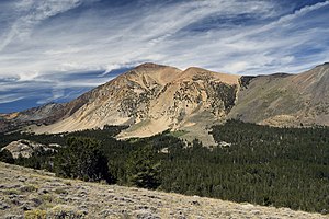
Dunderberg Peak
| Dunderberg Peak | ||
|---|---|---|
|
View of Dunderberg Peak from the southeast |
||
| height | 3774 m | |
| location | California , United States | |
| Mountains | Sierra Nevada | |
| Dominance | 5.19 km → Excelsior Mountain | |
| Notch height | 407 m | |
| Coordinates | 38 ° 3 '52 " N , 119 ° 16' 27" W | |
|
|
||
The Dunderberg Peak (formerly Castle Peak ) is a 3774 m high mountain on the eastern edge of the Sierra Nevada in the State of California of the United States . It is located in Mono County in the Hoover Wilderness .
The mountain lies on the eastern flank of the Sierra Nevada, in the east the landscape slowly merges into the western edge of the Great Basin . To the south and north are two valleys with several mountain lakes. The ghost town of Dunderberg Mill is located on the northeast flank . Peaks in the area are Camiaca Peak in the west, Black Mountain in the south and Mount Olsen in the southeast. The shore of Mono Lake is about 12 km to the southeast. The dominance is 5.19 km, so the mountain is the highest point within a 5.19 km radius. It is dominated by the south-southwest lying Excelsior Mountain .
Web links
- Dunderberg Peak in the Geographic Names Information System of the United States Geological Survey
- Data on the mountain
Individual evidence
- ↑ summitpost.org : Dunderberg Peak . Accessed March 1, 2019
- ↑ a b peakbagger.com : Dunderberg Peak, California . Accessed March 1, 2019


