Duvenackergraben
| Duvenackergraben | ||
|
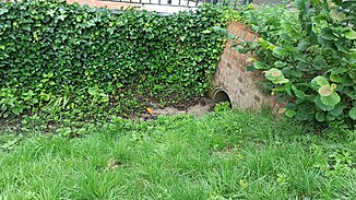
Source of the Duvenacker ditch on the Duvenacker road |
||
| Data | ||
| location | Hamburg-Eidelstedt | |
| River system | Elbe | |
| Drain over | Kollau → Tarpenbek → Alster → Elbe → North Sea | |
| source | East of the road Duvenacker 53 ° 36 '43 " N , 9 ° 54' 46" O |
|
| muzzle | on the street Niendorfer Gehege in the Kollau coordinates: 53 ° 36 '36 " N , 9 ° 55' 17" E 53 ° 36 '36 " N , 9 ° 55' 17" E
|
|
| length | 760 m | |
| Big cities | Hamburg | |
| Navigable | No | |
The Duvenackergraben is a 760 meter long ditch in Hamburg-Eidelstedt on the northwestern edge of the Free and Hanseatic City of Hamburg .
Its source is on the Duvenacker road not far west of the A 7 . From there it flows in a south-easterly direction, crosses under the Niendorfer Gehege street and the A7 and then also joins the Kollau on the Niendorfer Gehege street .
Individual evidence
- ↑ Justification for the development plan Eidelstedt 75 “Duvenacker”. Retrieved July 20, 2020 .
- ↑ Development plan Eidelstedt 75 determinations. Retrieved July 20, 2020 .
- ↑ Complete list of rivers in the Elbe catchment area. (PDF) Retrieved June 30, 2020 .
- ↑ BMBF PROJECT STUCK INTERIM REPORT. Retrieved July 20, 2020 .
