Dwiniza
|
Dwinitsa Dvinitsa |
||
|
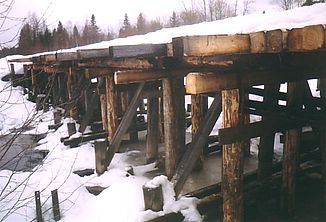
Dvinitsa near Semigorodnjaja |
||
| Data | ||
| Water code | RU : 03020100312103000007070 | |
| location | Vologda Oblast ( Russia ) | |
| River system | Northern Dvina | |
| Drain over | Suchona → Northern Dvina → White Sea | |
| source |
Kharkovsky mountain range 59 ° 53 ′ 34 ″ N , 40 ° 19 ′ 45 ″ E |
|
| muzzle |
Suchona coordinates: 59 ° 25 '27 " N , 40 ° 53' 35" E 59 ° 25 '27 " N , 40 ° 53' 35" E
|
|
| length | 174 km | |
| Catchment area | 2400 km² | |
| Discharge at the gauge Kotlaksa A Eo : 869 km² Location: 94 km above the mouth |
MQ 1952/1988 Mq 1952/1988 |
8.9 m³ / s 10.2 l / (s km²) |
| Left tributaries | Schorega , Korbanka , Vottscha | |
| Communities | Semigorodnjaja | |
The Dwiniza ( Russian Двиница ) is a left tributary of the Suchona in the Russian Oblast of Vologda .
The Dwinitsa rises on the Kharovsk ridge about 10 km southeast of Kharovsk . It flows in the upper reaches to the southeast along the southern flank of the Kharovsk ridge. The municipality of Semigorodnjaja is located on the middle reaches . Below the confluence of the Schorega from the left, the M8 road crosses the Dwinitsa. The Dwiniza finally flows into the left bank of the Suchona at river kilometer 433.
The Dwiniza has a length of 174 km. It drains an area of 2400 km². The mean discharge 94 km above the mouth is 8.9 m³ / s. The Dwiniza is fed to a large extent by the snowmelt . The river floods in April and May . Larger tributaries of the Dwiniza are Schorega, Korbanka and Vottscha (all from left).
Web links
Individual evidence
- ↑ a b Article Dwinitsa in the Great Soviet Encyclopedia (BSE) , 3rd edition 1969–1978 (Russian)
- ↑ a b Dvinitsa in the State Water Register of the Russian Federation (Russian)
- ↑ a b c Dwiniza at the Kotlaksa gauge - hydrographic data at R-ArcticNET
