East Cape (New Zealand)
| East Cape | ||
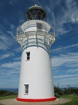
 East Cape with the East Cape Lighthouse |
||
| Geographical location | ||
|
|
||
| Coordinates | 37 ° 41 ′ S , 178 ° 33 ′ E | |
| location | Gisborne District , North Island | |
| Waters | Pacific Ocean | |
| length | 540 m | |
| width | 1 000 m | |
| height | 144 m | |
| lighthouse | East Cape Lighthouse | |
| particularities | easternmost point of the North Island | |

The East Cape is a cape in the Gisborne District on the North Island of New Zealand .
geography
The East Cape is located on the northeast tip of the North Island, 117 km north-northeast of Gisborne and 116 km east-northeast of Opotiki . The cape consists of a hill up to 144 m high, called Otiki , which stands out from a small plain surrounding it as far as the east coast. The hinterland of the East Cape is determined by a mountain landscape that rises from around 300 m with the Raukumara up to 1419 m and continues in the Raukumara Range .
The cape can be reached via the New Zealand State Highway 35 , also known as the Pacific Coast Highway , from Te Araroa . From the place branches off the East Cape Road , a 20 km long coastal road that leads directly to the cape.
East Cape Lighthouse
The East Cape Lighthouse , which is now on the Otiki , was originally built in 1900 on the island of East Island off the Cape and moved to the mainland in 1922 after the island's subsurface proved insufficiently stable.
Lighthouse Reserve
In June 2017 the Gisborne District Council designated a 70 hectare area around the lighthouse and towards the coast in order to be able to declare the area a protected area in a second step via the Tairāwhiti Management Plan . Trees such as Puriri and Tawa grow in the area and the scrubland consists of vegetation of New Zealand flax (Phormium cookanum) - narrow-leaved sticky seeds (Pittosporum tenuifolium) - South Sea myrtle , called Manuka and Kanuka (Kunzea ericoides). A special species of the plantain (Plantago picta) is considered an endangered species there.
tourism
The lighthouse is freely accessible from the outside of a car park and via a small hiking trail with around 700 steps. The tower itself cannot be climbed, but the old beacon, which was expanded in 2002, is on display on the tower.
Web links
Individual evidence
- ↑ a b Topo maps . Land Information New Zealand , accessed June 24, 2018 .
- ↑ Opotiki, East Cape & Beyond, Pacific Coast Highway Guide 2017 PDF Book . Gisborne City Specials , accessed June 24, 2018 .
- ↑ Tairawhiti Resource Management Plan . Gisborne District Council , accessed June 24, 2018 .
- ↑ G11 Schedule . (PDF 415 kB) Gisborne District Council , p. 9 , accessed on June 24, 2018 (English).
- ↑ Monty Soutar : East Coast places - East Cape . In: Te Ara - the Encyclopedia of New Zealand . Ministry for Culture & Heritage , March 30, 2015, accessed June 24, 2018 .

