Edward's trail
| Edward's trail | ||
|---|---|---|
|
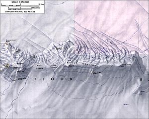
Topographic map (1: 250,000) of the Flood Range with the Edwards Spur (top center) |
||
| location | Marie Byrd Land , West Antarctica | |
| Mountains | Flood range | |
| Coordinates | 75 ° 59 ′ 0 ″ S , 135 ° 18 ′ 0 ″ W | |
|
|
||
The Edwards Spur is a rock spur with small protrusions on the summit ridge in Marie-Byrd Land in West Antarctica . It rises on the lower northwest slopes of Mount Moulton in the Flood Range .
The United States Geological Survey mapped it on the basis of its own surveys and aerial photographs of the United States Navy from 1959 to 1965. The Advisory Committee on Antarctic Names named it in 1974 after Alvah G. Edwards (1931–2005), United States Navy builder, who was involved in trips from Little America V station to the establishment of Byrd Station in 1956.
Web links
- Edwards track in the Geographic Names Information System of the United States Geological Survey (English)
- Edward's trail on geographic.org

