Iceberg (Reiter Alpe)
| iceberg | ||
|---|---|---|
|
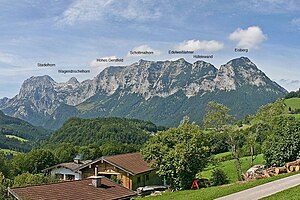
Reiter Alm with the iceberg in the north (right) |
||
| height | 1799 m above sea level NN | |
| location | Bavaria , Germany | |
| Mountains | Berchtesgaden Alps | |
| Coordinates | 47 ° 37 '33 " N , 12 ° 50' 50" E | |
|
|
||
| Normal way | Schwarzbachwacht - shot-in path - Eisbergscharte - Eisberg | |
The iceberg is a summit of the Reiter Alpe mountain range in the Berchtesgaden Alps . It has a height of 1799 m above sea level. NN and lies in the Berchtesgaden National Park .
Routes
- Schwarzbachwacht - shot-in path - Eisbergscharte - Eisberg
- Hintersee - Antonigraben - "Leiter" - Eisbergscharte - Eisberg
- Hintersee - Antonigraben - "Platte" - Eisbergscharte - Eisberg
The routes are not entered on the maps as official hiking trails and are not continuously marked. In addition to surefootedness , a sense of direction is necessary here.
Others
From the Eisbergscharte a transition to the Neue Traunsteiner Hut is possible. At the foot of the iceberg there is a national park service hut.

