
El Pinar (El Hierro)
| El Pinar municipality | |||
|---|---|---|---|
| coat of arms | Map of the Canary Islands | ||
 Help on coat of arms |
|
||
| Basic data | |||
| Autonomous Community : | Canary Islands | ||
| Province : | Santa Cruz de Tenerife | ||
| Island: | El Hierro | ||
| Coordinates | 27 ° 45 ′ N , 17 ° 59 ′ W | ||
| Height : | 800 msnm | ||
| Area : | 84.95 km² | ||
| Residents : | 1,870 (Jan 1, 2019) | ||
| Population density : | 22.01 inhabitants / km² | ||
| Postal code : | 38914, 38917 | ||
| Municipality number ( INE ): | 38901 | ||
| administration | |||
| Website : | www.aytoelpinar.org | ||
| Location of the municipality | |||

|
|||

El Pinar is one of the three communities on the Canary Island of El Hierro . It occupies the southern part of the island. The place of the same name is the administrative seat of the municipality. On September 15, 2007 El Pinar split off as an independent municipality from the municipality of La Frontera .
history
"El Pinar" refers to the Canarian pine , because the municipality has large areas of pine forest, which has shaped the lives of the residents for centuries.
For years the inhabitants fought for their independence. As a historic event , the new parish was inaugurated on September 15, 2007 with a large fiesta in the presence of the President of the Canary Islands, Paulino Rivero .
Places of the community
The population figures in brackets are from 2006.
- La Restinga (535 inhabitants)
- Las Casas (380 inhabitants)
- Taibique (876 inhabitants)
119 people live outside these localities.

Flag of El Pinar
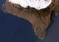
Satellite image of El Pinar, the pine forest and the trade winds on the mountain range are clearly visible

The port of La Restinga on the southern tip of El Pinar

View from the Mirador de Las Playas to the Punta de La Bonanza


Individual evidence
- ↑ Cifras oficiales de población resultantes de la revisión del Padrón municipal a 1 de enero . Population statistics from the Instituto Nacional de Estadística (population update).