Encarnación de Díaz
| Encarnación de Díaz | ||
|---|---|---|
|
Coordinates: 21 ° 32 ′ N , 102 ° 14 ′ W Encarnación de Díaz on the map of Jalisco
|
||
| Basic data | ||
| Country | Mexico | |
| State | Jalisco | |
| Municipio | Encarnación de Díaz | |
| City foundation | 1760 | |
| Residents | 25,010 (2010) | |
| City insignia | ||
| Detailed data | ||
| surface | 9.40 km 2 | |
| Population density | 2,661 inhabitants / km 2 | |
| height | 1850 m | |
| Website | ||
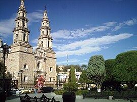
| Encarnación de Díaz - Church of Nuestra Señora de la Encarnación | ||
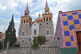
| Encarnación de Díaz - Church of Jesus Mary and Joseph | ||
| Encarnación de Díaz - Cemetery (cementerio) | ||
Encarnación de Díaz is a city with about 30,000 and the capital of a municipality ( municipio ) consisting of several villages and haciendas of about 60,000 in the Mexican state of Jalisco . The historic cemetery of the city belongs since 2010 to UNESCO - World Heritage Sites of Camino Real de Tierra Adentro .
Location and climate
The city of Encarnación de Díaz is just under 480 km (driving distance) northwest of Mexico City at an average altitude of approx. 1850 m ; to Guadalajara it is about 175 km in a south-westerly direction. The climate is warm; Rain (approx. 600 mm / year) falls predominantly in the summer half of the year.
Population development
| year | 2000 | 2005 | 2010 |
| Residents | 20,772 | 22,902 | 25,010 |
The slight but steady increase in population is mainly due to the ongoing immigration of families from the surrounding villages.
economy
Livestock raising (cattle, sheep, goats, pigs) plays the most important role in the life of the community; In addition, the cultivation of grain (maize, wheat, barley) and the cultivation of fruit and vegetables (beans, chillies, tomatoes, prickly pears, peaches, pears, figs, etc.) are important. Small traders, craftsmen and service providers of all kinds have settled in the city itself.
history
Before the arrival of the Spaniards, the area belonged to the Chichimec settlement area . The city, founded in 1760 by Manuel Agustín Calvillo, was close to the "Silver Road" (Camino Real de Tierra Adentro) that ran from Mexico City via Guanajuato to Zacatecas and further north.
Attractions
- The main church of the city (Paroquía de Nuestra Señora de la Encarnación) is a two- tower building from the 18th century; As with many churches in Mexico, only the central part of the facade is decorated with the portal covered by a multi-pass arch. The basement of the two towers, on the other hand, is largely unadorned, whereas the lower storeys in the upper part are richly structured and end in small lanterns . The single-nave church has side altars and a transept ; the crossing is vaulted by an illuminated dome .
- The two-tower Jesus-Maria- und Josef-Kirche is a central building from the years 1865 to 1881, vaulted by a huge dome, with numerous neo-Gothic elements inside and out.
- The main attraction of the city is the cemetery (Cementerio del Señor de la Misericordia) , which was laid out in the 18th century but enlarged in the 19th century, with its numerous wall graves in which mummified corpses were also found.
- Nearby is the Museo de las Ánimas de la Encarnación , which was rebuilt in the 1980s and presents some mummies as well as pre-Hispanic ceramic finds.


