Enehøje
| Enehøje | ||
|---|---|---|
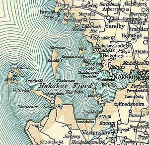
| Nakskovfjord with Enehøje on a map from around 1900 | ||
| Waters | Baltic Sea | |
| Geographical location | 54 ° 50 ′ 30 ″ N , 11 ° 1 ′ 0 ″ E | |
|
|
||
| length | 2.6 km | |
| width | 700 m | |
| surface | 1.01 km² | |
| Highest elevation | 16 m | |
| Residents | uninhabited | |
Enehøje is a Danish island in the Nakskovfjord , a side bay of the Great Belt on the west coast of Lolland, which has been uninhabited since the early 1990s . The island is 101 hectares and its highest point is 16 meters above sea level.
Enehøje is part of the parish ( Danish : Sogn ) Sandby ( Sandby Sogn ) parish, which belonged to Harde Lollands Nørre Herred in what was then Maribo Office until 1970 . From 1970 it belonged to the Ravnsborg municipality in what was then Storstrøms Amt , which was merged into the Lolland municipality in the Sjælland region with the municipal reform on January 1, 2007 .
From 1926 to 1940 the island was owned by the polar explorer and writer Peter Freuchen , who wrote some of his works here.
Enehøje is used for agriculture from neighboring Lolland.
Individual evidence
- ↑ Statistics banks -> Befolkning og valg -> BEF4: Folketal pr. January 1st demands på øer (Danish)
- ↑ Danmarks Statistics : Statistisk Aarbog 1990 - chap. 1: Befolkning og valg, table 3: Areal og folketal for landsdele og beboede øer (Danish; PDF; 1.2 MB)
- ↑ Enehøje ( Memento of the original from November 9, 2013 in the Internet Archive ) Info: The archive link was inserted automatically and has not yet been checked. Please check the original and archive link according to the instructions and then remove this notice. from www.nakskovfjord.dk, accessed November 9, 2013
- ↑ On a sightseeing flight in 1993 seen from Naskov, photographed and explained by the pilot.

