
Engelen ('s-Hertogenbosch)
 flag |
 coat of arms |
| province |
|
| local community |
|
|
Area - land - water |
13.40 km 2 11.34 km 2 2.06 km 2 |
| Residents | 5,760 (Jan 1, 2018) |
| Coordinates | 51 ° 43 ′ N , 5 ° 16 ′ E |
| Important traffic route |
|
| prefix | 073 |
| Postcodes | 5221 |
| Website | Homepage of Engelen |
 |
|
Engelen is a village in the municipality of 's-Hertogenbosch in the Dutch province of North Brabant . It is located on the Dieze and was an independent municipality from 1821 to 1971.
photos
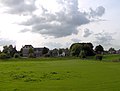
Village view

Church: de Sint Lambertuskerk

Memorial cross for victims of the Second World War


Web links
Commons : Engelen - collection of images, videos and audio files
- Place website (Dutch)
Individual evidence
- ↑ Kerncijfers wijken en buurten 2018 . In: StatLine . Centraal Bureau voor de Statistiek , February 1, 2019, accessed on February 27, 2019 (Dutch)