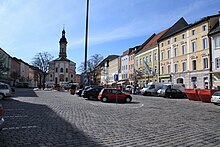
Ensemble Stadtplatz (Traunstein)
The Ensemble town square in Traunstein , the county town of the Upper Bavarian district of Traunstein is an architectural ensemble , under monument stands.
description
It includes the market square in the center of the old town on the raised terrace above the Traun , with its closed buildings, the free-standing parish church of St. Oswald in the western part and the approaches of Schaumburgerstrasse and Hofgasse, which branch off to the north-west and south-east at the top and bottom of the market.
The approximately 250-meter-long and 85-meter-wide square was created as a main, market and Schrannenplatz, probably in the middle of the 14th century as part of Ludwig's urban policy and the organization of salt trade and transport from Reichenhall via Traunstein to Munich. The salt depletion and the salt works since 1619 remained decisive for the development of Traunstein until the 19th century.
As a result of the great fires of 1704 and, above all, of 1851, the character of the old salt town, which was shaped by the Inn-Salzach construction method , dominates the development of the town square , but that of the largely uniform reconstruction after 1851. Three and four-storey eaves-sided bourgeois living and commercial buildings, brewery inns as well as official and communal buildings line the square. In the north and south they form closed plaza walls with facade structures in the style of the Maximilian era, late classicism and the neo-renaissance . However, new buildings in the second half of the 19th century partially impaired the appearance.
The western part of the town square is occupied by the baroque parish church of St. Oswald , which with the choir is directed towards the center of the square. The narrow town houses opposite the church, some of which are still provided with arbours on the ground floor , were spared from the city fires , as was the gate tower of the so-called Brothausturm .
On the narrow eastern front of the square, marking the passage to the lower suburb of Vorberg , rises the so-called Jacklturm , which was reconstructed from 1998 to 2000 and is linked to the late medieval buildings.
A row of three- to four-storey eaves-sided residential and commercial buildings built after 1851 connects to the east-facing buildings on Hofgasse. The plastered facades, simply structured in the style of the Maximilian era, and the mighty corner building of the Hofbräuhaus essentially determine the image of the alley leading from the town square to the area of the former nursing court on the southeast edge of the old town.
Individual monuments
- Lindlbrunnen
- Stadtplatz 1: Stadtpfarrkirche St. Oswald
- Stadtplatz 2/3: Gate tower of the former Upper or Munich Gate
- Stadtplatz 5: community center
- Stadtplatz 6: community center
- Stadtplatz 7: Mesnerhaus
- Stadtplatz 8: community center
- Stadtplatz 12: Marienapotheke
- Stadtplatz 20: Sternbräu
- Stadtplatz 21: rear building of the former brewery
- Stadtplatz 36 / 36a: residential and commercial building
- Stadtplatz 37: Gasthaus Höllbräu
- Stadtplatz 38: Former royal main salt office
- Stadtplatz 38a: Former district court
- Stadtplatz 39: Town Hall
literature
- Gotthard Kießling, Dorit Reimann: District of Traunstein (= Bavarian State Office for Monument Preservation [Hrsg.]: Monuments in Bavaria . Volume I.22 ). Kunstverlag Josef Fink, Lindenberg im Allgäu 2007, ISBN 978-3-89870-364-2 , p. 1019-1021 .
Web links
- List of monuments for Traunstein (PDF) at the Bavarian State Office for Monument Preservation
Coordinates: 47 ° 52 ′ 11 " N , 12 ° 38 ′ 55.4" E


