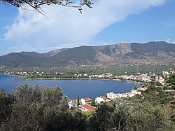
Eratini
|
Local community Eratini Τοπική Κοινότητα Ερατεινής (Ερατεινή) |
||
|---|---|---|
|
|
||
| Basic data | ||
| Country |
|
|
| region | Central Greece | |
| Regional district | Fokida | |
| local community | Dorida | |
| Parish | Tolofona | |
| Geographic coordinates | 38 ° 22 ' N , 22 ° 14' E | |
| Height above d. M. |
15 m (average) |
|
| surface | 3,400 km² | |
| Residents | 856 (2011) | |
| LAU-1 code no. | 31020401 | |
| Local division | 1 | |
| Post Code | 33058 | |
| Telephone code | +30 (22660) | |
| Eratini Bay | ||
Eratini ( Greek Ερατεινή ( f. Sg. )) Is a village in the Central Greek municipality of Dorida on the north bank of the Gulf of Corinth . Between 1997 and 2010 Eratini was the administrative seat of the former municipality of Tolofona , which was incorporated into the newly created municipality of Dorida as a result of the administrative reform in 2010 .
Eratini is 14 km west of Galaxidi , 19 km south of Lidoriki , 23 km southwest of Amfissa and 35 km east of Nafpaktos . It is located on the Greek national road 48 ( Andirrio - Nafpaktos - Delfi - Livadia ).
Residents
| year | Residents |
|---|---|
| 1981 | 529 |
| 1991 | 572 |
| 2001 | 726 |
| 2011 | 856 |
Individual evidence
- ↑ Results of the 2011 census at the National Statistical Service of Greece (ΕΛ.ΣΤΑΤ) (Excel document, 2.6 MB)

