Eratosthenes (moon crater)
| Eratosthenes | ||
|---|---|---|

|
||
| Eratosthenes and its surroundings | ||
|
|
||
| position | 14.47 ° N , 11.35 ° W | |
| diameter | 59 km | |
| Card sheet | 58 (PDF) | |
| Named after | Eratosthenes (around 275–194 BC) | |
| Named since | 1935 | |
| Unless otherwise stated, the information comes from the entry in the IAU / USGS database | ||
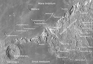
Eratosthenes is a large, very deep moon crater a little northwest of the visible center of the moon. It lies at the transition between the basalt basins of Mare Imbrium and Sinus Aestuum and marks the western end of the Apennine mountains. On the lunar timescale , the longest and most stable epoch - the Eratosthenic period - was named after this crater. It began with its impact 3.15 billion years ago and ended 1.0 billion years ago.
Eratosthenes has sharply defined, ring-shaped crater walls , the steep inner side of which is divided into terraces . The crater floor is uneven and has three central mountains . When the moon is full, you can see some rays from the nearby, much younger ring mountain range of Copernicus .
| Letter | position | diameter | link |
|---|---|---|---|
| A. | 18.32 ° N , 8.34 ° W | 6 km | [1] |
| B. | 18.69 ° N , 8.71 ° W | 5 km | [2] |
| C. | 16.88 ° N , 12.4 ° W | 5 km | [3] |
| D. | 17.43 ° N , 10.91 ° W | 4 km | [4] |
| E. | 17.92 ° N , 10.9 ° W | 4 km | [5] |
| F. | 17.68 ° N , 9.91 ° W | 4 km | [6] |
| H | 13.31 ° N , 12.26 ° W | 3 km | [7] |
| K | 12.83 ° N , 9.27 ° W | 4 km | [8th] |
| M. | 14.01 ° N , 13.6 ° W | 4 km | [9] |
| Z | 13.73 ° N , 14.11 ° W | 2 km | [10] |
Web links
- Eratosthenes in the Gazetteer of Planetary Nomenclature of the IAU (WGPSN) / USGS
- Eratosthenes Astrogeology Science Center
- Full Moon Atlas (interactive) Section D3, Eratosthenes and Copernicus
- Eratosthenes Digital Lunar Orbiter Photographic Atlas of the Moon
- Eratosthenes @ The moon

