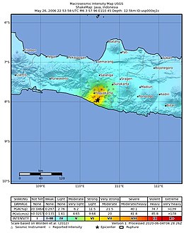
Yogyakarta earthquake in 2006
| Yogyakarta earthquake Bantul earthquake |
||
|---|---|---|
|
|
||
| date | May 26, 2006 UTC | |
| Time | 22:53:58 UTC | |
| intensity | VIII on the MM scale | |
| Magnitude | 6.3 M W | |
| depth | 12.5 km | |
| epicenter | 7 ° 57 '40 " S , 110 ° 26' 46" E | |
| country | Indonesia | |
| dead | at least 5,716 | |
| Injured | at least 37,927 | |
| damage | at least 3 billion USD | |
The Yogyakarta earthquake shook the ground on May 27, 2006 at 5:53 am local time . The earthquake with a magnitude of 6.3 M W had its epicenter in the Sultanate of Yogyakarta on the Indonesian island of Java . More than 5,700 people were killed in the disaster and at least 37,000 were injured. More than 350,000 buildings were destroyed or damaged.
tectonics
The island of Java lies on the Lesser Sunda Plate , under which the Australian Plate subducts in the Sunda Trench . Earthquakes in the area are often related to this plate boundary , but the May 27, 2006 quake was solely an intraplate quake on the Sundaplatte. There may be an indirect connection with the subduction process, which could have induced stress accumulation on the upper crust.
There are certain uncertainties in the interpretation of seismological data due to faulty seismographs . So give different seismic stations magnitudes 6.2 to 6.4 M W to. According to the United States Geological Survey , the epicenter of the quake was around 20 kilometers southeast of downtown Yogyakarta and its hypocenter was 12.5 kilometers deep. The area of the hearth is estimated to be around 20 × 10 kilometers . The tremors lasted for about 60 seconds, an unusually long period for the strength of the quake.
The hearth event was either a pure side shift or, more likely, a side shift with a shift component . The epicenter was located on the sinistral Opak- rejection (named after the nearby river opaque ). The quake was followed by numerous aftershocks, the epicentres of which were mainly around five kilometers east of the Opaque Fault.
There may be a connection between the increased activity of the Merapi volcano and the earthquake.
Victims and damage
| province | Administrative district | dead | Injured |
|---|---|---|---|
| Yogyakarta | Bantul | 4.121 | 12,026 |
| Sleman | 240 | 3,792 | |
| Yogyakarta | 195 | 318 | |
| Gundungkidul | 81 | 1,086 | |
| Kulonprogo | 22nd | 2,179 | |
| Central Java | Clap | 1,041 | 18,127 |
| Magelang | 10 | 24 | |
| Boyolali | 4th | 300 | |
| Sukoharjo | 1 | 67 | |
| Purworejo | 1 | 4th | |
| Wonogiri | 0 | 4th | |
| total | 5,716 | 37,927 | |
The hardest hit areas were the administrative districts of Bantul in Yogyakarta and Klaten in central Java . In some areas in the alluvial plain , the tremors were particularly destructive due to soils with loose sediments . According to an evaluation by regional and local authorities published in June 2006, the earthquake killed 5,716 people and injured 37,927. This information is viewed as the lower limit of the actual number of victims, according to other information there were 60,000 injured.
According to the same evaluation, at least 156,000 buildings were destroyed and more than 200,000 damaged. Very few residential buildings in the densely populated region were built to be earthquake-proof .
Many health facilities were affected by the quake; 17 hospitals had to close in the city of Yogyakarta alone. 2,155 educational institutions were destroyed or damaged. Many religious institutions were damaged. Serious damage was caused to the UNESCO World Heritage Site of the Prambanan Hindu temple complex .
Roads and bridges were affected over a total length of about 49 kilometers. The damaged Yogyakarta airport resumed operations for aid deliveries two days later. There was relatively little damage to utility networks. The economic damage from the earthquake has been estimated to be at least $ 3 billion.
The earthquake panicked people for fear of a possible tsunami . Thousands spent the nights outdoors in fear of aftershocks. Heavy rain and persistent power outages hampered the rescue work. Numerous states as well as the UN offered help.
literature
- Amr S. Elnashai, Sung Jig Kim, Gun Jin Yun, Djoni Sidarta: The Yogyakarta Earthquake of May 27, 2006. Mid-America Earthquake Center Report No. 07-02, 2007, online (PDF; 9.11 MB) at mae.cee.illinois.edu (English).
supporting documents
- ↑ a b M 6.3 - Java, Indonesia. USGS, accessed July 23, 2020.
- ↑ Birger-G. Lühr, Thomas Walter, Joachim Wassermann, Ade Anggraini, Rongjang Wang, Diana Wagner, Stefano Parolai, Jochen Zschau, Prih Harjadai: The Mw 6.4 Bantul earthquake 2007 - a surprising disaster? In: 68th Annual Meeting of the German Geophysical Society. Pp. 209f., Online (PDF; 2.68 MB) at tu-freiberg.de.
- ^ R Budiman, DP Sahara, AD Nugraha: Determining Source Model and Aftershocks of 2006 Yogyakarta Earthquake, Indonesia using Coulomb Stress Change. In: IOP Conference Series: Earth and Environmental Science. Volume 318, 2019, pp. 1–8, DOI: 10.1088 / 1755-1315 / 318/1/012026 (English).
- ↑ Anett Keller: Earthquake in Indonesia: "Everything screamed tsunami, tsunami". In: spiegel.de . May 27, 2006, accessed August 4, 2020.
- ↑ Earthquake on Java: helpers desperate, continuous rain hinders rescue work. In: spiegel.de . May 29, 2006, accessed August 4, 2020.

