Eschtemoa

Eschtemoa ( Hebrew אשׁתמע 'Eshtemoa' ) is a place mentioned several times in the Hebrew Bible . In Roman and Byzantine times, Eschtemoa was a large Jewish village (spellings in the Onomasticon of Eusebius : Ασθεμω, Εσθεμω, Εσθαμα). Identification with the village of Samū ‛ in the West Bank is considered certain. Samu ' is located about 15 kilometers south of Hebron in a strategic position, since the place in the north and east is protected by deep valleys, at the same time access to an important historical Road, the north-south connection Shechem - Hebron - Arad , has .
Ancient synagogue
After earlier visitors to the village had noticed ancient spoils , Leo Arye Mayer and Adolf Reifenberg located the synagogue at the highest point in 1934 and excavated it from 1935–1936 on behalf of the Hebrew University . In 1969–1970, Zeev Yeivin led rescue excavations and restorations.
The synagogue of Eschtemoa, a building of the 3rd / 4th century. Century, follows the Breithaus type. Two steps lead from a paved forecourt to the narthex with a row of columns that are still in evidence. Through a rebuilt main portal, the visitor enters a synagogue room with the internal dimensions 21 × 11 m. The side walls are still up to a height of 8.5 m. On the north wall (i.e. towards Jerusalem) there was a stone podium ( bima ) with a base area of about 1.5 × 4.5 m. At a height of a good 2 meters you can see three niches set into the wall; the middle one was the Torah shrine .
Silver treasure
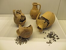
In 1971, an Iron Age silver treasure came to light during restoration work in the northwestern side room of the synagogue. Five jugs contained a total of about 26 kilos of silver: rings, leaves, threads, jewelry, crescents, lumps. The purpose of this landfill is unknown. It may be a hiding place in connection with Sennacherib's campaign (701 BC).
Web links
- Erasmus Gass : Eschtemoa. In: Michaela Bauks, Klaus Koenen, Stefan Alkier (Eds.): The Scientific Biblical Lexicon on the Internet (WiBiLex), Stuttgart 2006 ff.
literature
- Othmar Keel, Max Küchler: Places and landscapes of the Bible. A handbook and study guide to the Holy Land. Volume 2: The South. Göttingen 1982. ISBN 3-525-50167-6 . Pp. 762-765.
Coordinates: 31 ° 24 ′ 2.9 ″ N , 35 ° 4 ′ 1.5 ″ E
