Ewyas Harold
| Ewyas Harold | ||
|---|---|---|
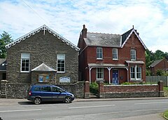
| The Ewyas Harold Baptist Church | ||
| Coordinates | 51 ° 57 ′ N , 2 ° 53 ′ W | |
| OS National Grid | SO 38862 28567 | |
|
|
||
| Residents | 883 (as of 2011) | |
| surface | 7.49 km² (2.89 mi² ) | |
| Population density: | 118 inhabitants per km² | |
| administration | ||
| Post town | HEREFORD | |
| ZIP code section | HR2 0TY | |
| Part of the country | England | |
| region | West Midlands | |
| Ceremonial county | Herefordshire | |
| Unitary authority | Herefordshire | |
| Civil Parish | Ewyas Harold | |
| ONS code | E04000756 | |
| British Parliament | Hereford and South Herefordshire | |
| Website: ewyasharoldgpc.org.uk | ||
Ewyas Harold is a village and civil parish in Herefordshire in the West Midlands region of England . The Civil Parish had 883 residents in 2011.
geography
Ewyas Harold is located about 75 meters above sea level in the west of England near the border with Wales and thus in the west of the Herefordshire. The Civil Parish borders the Grosmont community in the Welsh Monmouthshire in the south . However, all other borders run within England. There are shared borders in the west with Rowlstone and Dulas , in the north with Abbey Dore and in the east with Kilpeck and Kentchurch . Through the Civil Parish and the town, which is the main town in addition to a few small settlements, the Dulas Brook is a larger stream that flows into Ewyas Harold with the Iss . In addition, the Pontrilas Road runs through the Civil Parish ; in the east, the Civil Parish also has the A465 road as another larger road in its area. In addition, some forests and parts of the Pontrilas Army Training Area are in the area of Ewyas Harold.
history
Ewyas Harold, named after a Harold of Ewias who owned the Ewyas Harold Castle , is one of the villages mentioned in the Domesday Book of 1086. In this it is stated that at that time the area was divided between three owners (including Henry de Ferrers ) and it had a little over 30 households.
Population development
| year | 1801 | 1811 | 1821 | 1831 | 1841 | 1851 | 1861 | 1871 | 1881 | 1891 | 1901 | 1911 | 1921 | 1931 | 1941 | 1951 | 1961 | 1971 | 1981 | 1991 | 2001 | 2011 |
|---|---|---|---|---|---|---|---|---|---|---|---|---|---|---|---|---|---|---|---|---|---|---|
| Residents | 342 | 317 | 412 | 344 | 356 | 392 | ? | 548 | 543 | 507 | 476 | 471 | 449 | 461 | ? | 548 | 504 | ? | ? | ? | ? | 883 |
traffic
Two different bus routes have stops in Ewyas Harold.
Infrastructure
Ewyas Harold has his own Royal Mail post office . In addition to the Ewyas Harold Baptist Church , the village also has an Anglican church, St Michael's Church . The church is from the 13th century and is, among other things, the repository of a portrait of a woman holding a heart dating back to the 14th century.
Buildings
A total of seven buildings in the Civil Parish area have been included in the Statutory List of Buildings of Special Architectural or Historic Interest , all as Grade II buildings . These include various farmhouses, but also parts of the Anglican Church.
Web links
- Ewyas Harold's website
- Website of the Ewyas Harold Group Parish Coucils
Individual evidence
- ↑ a b c d e Ewyas Harold Parish - Local Area Report. In: nomisweb.co.uk. University of Durham , accessed July 28, 2020 .
- ↑ Ewyas Harold, County Of Herefordshire. In: getoutside.ordnancesurvey.co.uk. Ordnance Survey, accessed June 28, 2020 .
- ^ Election Maps. Ordnance Survey, accessed on June 28, 2020 (English, To get to the Civil Parish Ewyas Harold: Please check the Parishes tab in the Parishes section in front of Civil Parishes or Communities and then enter "Ewyas Harold" in the search field on the right. ).
- ↑ a b David Ross: Ewyas Harold, St Michael's Church. Britain Express, accessed June 28, 2020 .
- ^ Anna Powell-Smith: Ewyas Harold. Open Domesday, accessed on June 28, 2020 .
- ^ Ewyas Harold AC / CP through time. In: A Vision Of Britain Through Time. University of Portsmouth , accessed June 27, 2020 .
- ↑ Ewyas Harold. bustimes.org, accessed June 28, 2020 .
- ↑ Ewyas Harold. Royal Mail , accessed June 28, 2020 .
- ↑ St Michael'S, Ewyas Harold, HR2 0TX. Diocese of Hereford, accessed June 28, 2020 .
- ^ Listed Buildings in Ewyas Harold, Herefordshire ,. British Listed Buildings, accessed June 28, 2020 .

