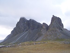
Krossanesfjall
| Krossanesfjall | ||
|---|---|---|
|
Eyststraorn |
||
| height | 716 m | |
| location | Eastern Iceland | |
| Coordinates | 64 ° 26 '44 " N , 14 ° 32' 16" W | |
|
|
||
| Type | volcano | |
|
Western side of the Eystrahorn |
||
The mountain Krossanesfjall is an extinct volcano in Iceland . It is located in the south-east of the country not far from the town of Höfn and is 716 m high. In the Ice Age it formed part of the central volcano of Lón , probably also the edge of the caldera .
Road connection on the mountain
In earlier times you had to negotiate a 15 km long and 390 m high mountain path over the Lónsheiði plateau to get from Lón to the Álftafjörður area .
Today the ring road winds around Hvalnesskriður and Krossanesfjall. Proper names like Illskúti (dt. Evil hollowing out ) u. point out how dangerous it seemed to people in earlier times to walk this path, especially because of the danger of falling rocks from the erosion slopes of the mountain. Especially since there is another similar slope to the east, the so-called Þvottárskriður , which is the remains of the also extinct Álftafjörður volcano .
This risk has not been completely eliminated in the meantime, but has been significantly reduced by good road construction.
In bad weather and in winter, however, the road can be closed to be on the safe side, so people in the area are calling for a tunnel to be built.
Eystrahorn and Vestrahorn
Part of the Krossanesfjall is the famous Eystrahorn (also Austurhorn ) rock outcrop , to which the Vestrahorn (sometimes also: Vesturhorn ) (757 m) corresponds on the other side of the wide bay of Lón . The Eystrahorn is also called Hvalnesfjall because of the now abandoned Hvalnes farm at its foot. Both mountains are believed to be intrusions and consist of magma that slowly cooled below the surface of the earth. At the same time, they probably formed the edge of a large caldera that filled today's Lón Bay. In any case, there was a large central volcano here that was active about 6-7 million years ago.
Both the Vestrahorn and the Eystrahorn consist of two different deep rocks : Gabbro and Granophyr . Sometimes rock can also be found in which one type of rock forms inclusions in the other. The same can be explained by the following process: First, basic magma can collect here in a pocket or crevice, then this rhyolite magma is injected into this rhyolite magma in a pulsating rhythm. It does happen that basic and acidic magma originate in the same magma chamber.
The mountain peaks owe their current appearance to erosion by glaciers, wind and water. And thanks to their special type of rock, the Eystrahorn and Vestrahorn have more in common with mountains in the Alps than with the basalt or rhyolite mountains common in Iceland .
See also
Web links
- Tanya Furmani, ea: Petrogenesis of Evolved Basalts and Rhyolites at Austurhorn, Southeastern Iceland: the Role of Fractional Crystallization , Journal of Petrology 1991 (Abstract, English)
Individual evidence
- ^ A b c Thor Thordarson, Armann Hoskuldsson: Classic Geology in Europe 3. Iceland. Harpenden 2002, p. 126
- ↑ Íslandshandbókin. Náttúra, saga og sérkenni. 2. bindi. Edited by T. Einarson, H. Magnússon. Reykjavík (Örn og Örlygur) 1989, p. 682
- ↑ Íslandshandbókin. Náttúra, saga og sérkenni. 2. bindi. Edited by T. Einarson, H. Magnússon. Reykjavík (Örn og Örlygur) 1989, p. 654
- ↑ Ari Trausti Guðmundsson: Living Earth. Facets of the geology of Iceland. Reykjavík 2007, p. 50


