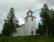
Fatmomakke
| Fatmomakke | ||||
|
||||
| State : | Sweden | |||
| Province (län): | Västerbotten County | |||
| Historical Province (landskap): | Lapland | |||
| Municipality : | Vilhelmina | |||
| Coordinates : | 65 ° 5 ' N , 15 ° 9' E | |||
Fatmomakke ( South Sami Faepmie ) is a settlement in the Swedish municipality of Vilhelmina in the historical province of Lapland and the province of Västerbotten County . Fatmomakke is about 120 kilometers away from Vilhelmina at the foot of the Marsfjäll . The name means "place where you can hug".
history
Even before Sweden settled the place for the first time as part of the colonization of Lapland, the place was a meeting point for the Sami people . In 1781 the first chapel was finally built on site; the church festivals held there were at first only attended by Sami. Little by little, cottages and houses were built around the chapel, where the Sami could stay during church festivals. From 1820 on, non-Sami finally settled and settled in the place, and a lively cultural exchange between settlers and Sami developed. In 1881 the church, which had become too small and out of date, was replaced by a new one.
Web links
- Ankarede and Fatmomakke on the Wilderness Road website (Swedish, German, English, Dutch)
- Information on Fatmomakke on the Church of Sweden website (Swedish)

