Fauresmith
| Fauresmith | ||
|---|---|---|
|
|
||
| Coordinates | 29 ° 45 ′ 0 ″ S , 25 ° 19 ′ 0 ″ E | |
| Basic data | ||
| Country | South Africa | |
| free State | ||
| District | Xhariep | |
| ISO 3166-2 | ZA-FS | |
| local community | Kopanong | |
| surface | 52.1 km² | |
| Residents | 1430 (2011) | |
| density | 27.4 Ew. / km² | |
| founding | 1842 | |
| Website | www.fauresmith.co.za (Afrikaans and English) | |
|
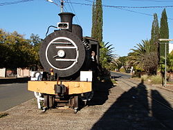
SAR class 8BW on the main road
|
||
Fauresmith is a town in the municipality of Kopanong in the Xhariep District ( Free State Province ) in South Africa with 1430 inhabitants (as of 2011). The neighboring township of Ipopeng has 2198 inhabitants. Fauresmith is 130 kilometers southwest of Bloemfontein .
Prehistory and History
The Fauresmith complex was named after the place, which has relatively small hand axes as a characteristic .
Before the Boers arrived , Griqua lived in the area. The immigrant Boers founded Fauresmith in 1842, the second oldest town in what was then the Orange Free State . The town charter was granted on December 13, 1859. The name of the city is made up of the surnames of Philip Faure, Reverend of the Dutch Reformed Church , and Sir Harry Smith , Governor of the Cape Colony . The town's farmers mainly grew alfalfa and potatoes .
traffic
Fauresmith is connected to Koffiefontein and Trompsburg via the R704 road. The city is also located on the disused Springfontein –Koffiefontein railway line . The route runs right through the town on the main road. The last train ran here in 1999. A monument locomotive was set up on the main road right next to the main line. It is SAR class 8BW No. 1153, which was built in 1903 by the North British Locomotive Company .
Web links
- Fauresmith on www.places.co.za (English)
- Description of the monument locomotive (English)
- Information and pictures of the railway line (English)
Individual evidence
- ^ Fauresmith , accessed November 25, 2013
- ↑ Ipopeng , accessed on July 7, 2017

