Fearn Airfield
| Fearn Airfield | |
|---|---|

|
|
| Characteristics | |
| Coordinates | |
| Transport links | |
| Distance from the city center | 2 km southeast of Hill of Fearn , 2 km west of Balintore |
| Street | 7 km to the |
| Basic data | |
| opening | 1941 |
| Runways | |
| 05/23 | 1340 m × 45 m macadam |
| 11/29 | 1150 m × 45 m macadam |
| 18/36 | 1070 m × 45 m macadam |
Fearn Airfield is a former military airfield in the Highland region of Scotland . It is roughly halfway between the villages of Balintore and Hill of Fearn and around nine kilometers southeast of Tain .
history
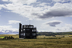
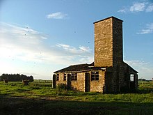
In 1940 the British Air Force began construction of the airfield, which they wanted to use as an adjacent airfield to the Tain military airfield . In 1941 it was commissioned as RAF Fearn. Since the Fleet Air Arm of the British Navy also used the Tain airfield for training flights, but this was increasingly reaching the limits of its capacity, it was decided to transfer Fearn to the naval aviators. It was handed over in the summer of 1942. Due to the tradition of the British Navy to designate their ashore facility as a ship, it was from then on under the name HMS Owl. The airport was immediately supplemented by a larger number of other structures, including the replacement of the one-story observation and control building that had existed up to that point with a four-story tower .
The first unit to use the airport was the 825th Squadron, equipped with Swordfish machines . As a result, training flights were carried out almost exclusively, including for newly established units. Mainly machines of the newly developed type Barracuda were used , especially the use as torpedo bombers was practiced .
After the end of the Second World War , the airfield was closed in 1946, but was held as an alternative landing field for the Dalcross military airfield, which later became today's Inverness Airport , until the early 1950s . It remained subordinate to the Ministry of Aviation until 1957 , after which it was sold to private landowners. In 1974 the Cromarty Firth Development Company purchased the site to build a civil airfield. This Cromarty Firth Airport should be operated by Loganair and benefit from the economic upturn in the little south of Nigg . At the time, a large number of oil platforms were installed there; today they are wind turbines. The project was not implemented.
description
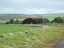
The facility had three runways that were offset by around 60 ° and all three intersected. The railways ended on both sides at a ring road, within which otherwise only the tower in the east with a few auxiliary buildings was. A number of buildings, including hangars and shelters, were scattered around the ring road. The access was in the east, there were also other technical facilities.
Two further, separately located complexes belonged to the base. One was about a kilometer to the east in the area of the Balintore Farm, it was mainly used as accommodation for the soldiers. The other, one kilometer to the northeast, on the area of the Loans of Tullich, also known as The Wrennery , included, among other accommodations, the officers' mess , a hospital, a cinema and a building for decontamination in the event of an attack with poison gas.
Current condition
The runways are still there today, but due to a lack of maintenance they can no longer be used for regular flight operations. Only the runway running in a north-west-south-east direction was kept in good shape so that it could be used in emergencies and for touch-and-go maneuvers during training flights, the other two are mainly used as storage space for agriculture. Field crops are grown in large parts of the interior. The buildings outside the ring, as well as on the two external areas, have partly disappeared, partly in the process of decay, some are used as shelters for agriculture, privately or for small businesses. The entire site is designated as a commercial area under the name Fearn Drome . The Tower, which since 2000 as Listed Building category C listed building stands was still the beginning of the 2010s in a ruinous state, but was then purchased by a couple who renovated it and adapting it to the house.
In the Loans of Tullich area, there are also a number of buildings, some as ruins, some used, but all in poor condition. Only one building remains of the complex near Balintore Farm, the rest have been demolished.
In 2010 a concept was presented to set up a wind farm on the site . The project with a total of four rotors has been in the scoping phase since 2014 .
The border between two municipalities runs right across the airport grounds, the southwest belongs to Nigg and Shandwick, the northeast as well as the two separate complexes to Balintore and Hilton. In 2008, a private take-off and landing area called Easter Airfield was opened immediately south of the boundary of the airport . It has nothing to do with the former military airport.
In 2017 the Toulvaddie Distillery was founded by Heather Nelson on the spacious grounds . This is the first whiskey distillery to be founded by a woman in Scotland after 200 years. The annual production is 30,000 liters.
literature
- Pete Higgins: Fearn Airfield Control Tower. Cromarty 2012. ( Digitized on the website of the Historic Environment Record of the Highland Council, PDF, 3.8 MB; English)
- David Lynn: Fearn Wind Energy Project. Glasgow 2010. ( Digitized on the Orkney Sustainable Energy Ltd website, PDF, 2.9 MB; English)
- ASH Consulting Group: Second Worls War Airfields at Tain and Fearn, Easter Ross. Inverness 1999. ( Digitized on the website of the Historic Environment Record of the Highland Council, PDF, 109 MB; English)
Web links
- Fearn Airfield and Barracks, Loans of Tullich on the Historic Environment Record website of the Highland Council
- Entry on Fearn Airfield in Canmore, Historic Environment Scotland's database; Entry on Balintore Farm in Canmore, Historic Environment Scotland database; Entry on Loans of Tullich in Canmore, Historic Environment Scotland's database; Entry on Control Tower in Canmore, Historic Environment Scotland's database
- Fearn Airfield at secretscotland.org (English)
- Fearn Airfield at forgottenairfields.com (English)
- HMS Owl on the Tain Museum website
- Fearn Airfield on the Cromarty Archives website
Individual evidence
- ↑ Listed Building - Entry . In: Historic Scotland .
- ↑ Information about the project on the website of the Highland Council, accessed on October 16, 2015 (English)
- ↑ Easter Airfield under threat from wind turbines ( Memento of the original from June 27, 2015 in the Internet Archive ) Info: The archive link was inserted automatically and has not yet been checked. Please check the original and archive link according to the instructions and then remove this notice. . FLYER, February 10, 2015, accessed on October 16, 2015
- ↑ Website of the airfield , accessed on October 16, 2015 (English)
- ↑ Toulvaddie Distillery Homepage (English)
- ↑ Information on the Toulvaddie Distillery

