Fiery Cross Atolls
| Fiery Cross Atolls | ||
|---|---|---|
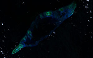
| Landsat 7 image of the atoll (April 2000) | ||
| Waters | South China Sea | |
| archipelago | Spratly Islands | |
| Geographical location | 9 ° 37 ' N , 112 ° 58' E | |
|
|
||
| Number of islands | 1 | |
| Main island | artificial island at Dhaulle Shoal in the southwest | |
| length | 25.5 km | |
| width | 7.6 km | |
| Land area | 2.3 km² | |
| total area | 105 km² | |
| Highest elevation | 1 m | |
| Residents | 200 | |
| Oblique aerial image (May 2015) | ||
Fiery Cross Atolls ( Chinese 永 暑 礁 , Pinyin Yǒngshǔ Jiāo or Fiery Cross Reef ; Filipino : Kagitingan ; Vietnamese : Đá Chữ Thập ) is an atoll of the Spratly Islands in the South China Sea . The largely submerged atoll, whose reefs form a round shape, has a total area of 105 km², the maximum extent of the reef formations has a length of 25.5 km and a width of 7.6 km from northeast to southwest. The numerous reefs and sandbanks are largely below the water level at high tide. The lagoon is only faintly recognizable and has a depth of 14.6 m to 39 m. At low tide a reef ( 9 ° 33 ' N , 112 ° 53' E ) rises about 1 m above the water surface on the southwestern edge of the atoll , and another about 0.6 m in the northeast. Yongshu Jiao is a good 1370 km from mainland China and 1020 km from the port of Yulin Gang near Sanya on the island of Hainan . The island lies roughly in the middle on an imaginary line from Taiping Dao to Nanwei Dao (南威 die, Spratly Island ).
Fiery Cross Atolls are administered by the People's Republic of China as part of the city of Sansha in its Hainan Province , the Philippines , Vietnam and the Republic of China are claiming the island as part of the territorial conflicts in the South China Sea .
history
The government of the Republic of China first officially assigned a Chinese place name, Shizi Huojiao (十字 火 礁) , to the island in 1935 , which was changed to its current name by another government decree in 1947.
In March 1987, the UNESCO Oceanographic Committee decided that China should build Oceanographic Observation Station No. 74 on its behalf. In the following year, the Chinese government selected Yongshu Jiao for this purpose and erected emblems and a total of ten beacons (航标 灯), towers with a height of 7 m and a diameter of 1.8 m on five reefs .
In 1988 the south-western rock, on which there are guano deposits, was expanded to almost 9,000 m² and a naval surveillance base with a military port and a permanent garrison of 200 marines from the Chinese People's Liberation Army was built. There were also plantings of coconut palms , banyan trees and conifers.
Since 2011 the island has been the seat of the high command of the Chinese naval forces in the area of the Nansha Islands, equipped with facilities for data transmission via satellite, radar systems, artillery and several machine-gun bases. China Mobile has connected Yongshu Jiao and the surrounding sea area to the Chinese cell phone network. The UNESCO oceanographic observation station is in permanent operation on the island . There is also a two-story residential building and a 500 m² greenhouse for growing vegetables.
In the second half of 2014, the People's Republic of China expanded the island to include a three-kilometer-long and up to 300-meter-wide sand heap. An airfield with a runway , an expansion of the existing port and extended coastal protection walls were created. After the expansion of Chigua Jiao , Huayang Jiao and Nanxun Jiao, it is the fourth artificial island expansion that was carried out by China under the Nansha Islands.
By February 2015, the area of the artificial island had grown to around 230 hectares, exceeding the largest natural of all the Spratly Islands, Taiping Dao , by five times.
There are plans for the entire atoll, which is over 25 kilometers long.
Administrative structure
The "hypothetical large community " Yongshu Jiao (永 暑 礁 虚拟 镇) is divided into:
- Hypothetical the population Community Yongshujiao (永暑礁虚拟社区); and the
- Meiji Village (美 济 村), on Meiji Jiao .
Large community and community of residents are currently "hypothetical", as there is no civilian population on Yongshu Jiao and the military personnel are not subject to civil administration. However, since the village of Meiji already has a civilian population, the "hypothetical" situation is likely to end in the near future.
See also
swell
- Koo, Min Gyo: Island Disputes and Maritime Regime Building in East Asia. Between a Rock and a Hard Place. Dordrecht, Heidelberg, London, New York: Springer 2010. ISBN 978-1-4419-6223-2 . P. 153ff.
Individual evidence
- ↑ Dispute over raw materials: China builds fourth artificial island . Spiegel Online, November 28, 2014, accessed on the same day.
- ^ What is China Building in the South China Sea? . Retrieved April 6, 2015.
- ↑ James Hardy, London and Sean O'Connor: China building airstrip-capable island on Fiery Cross Reef


