Findhorn (river)
| Findhorn | ||
|
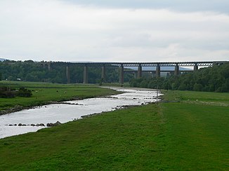
The Findhorn with the bridges of the Highland Main Line and the A9 , east of Tomatin |
||
| Data | ||
| location | Scotland | |
| source | in the Monadhliath Mountains, 57 ° 5 ′ 38 " N , 4 ° 18 ′ 16" W |
|
| Source height | approx. 850 m | |
| muzzle | at Findhorn coordinates: 57 ° 39 '49 " N , 3 ° 37' 57" W 57 ° 39 '49 " N , 3 ° 37' 57" W. |
|
| Mouth height | 0 m | |
| Height difference | approx. 850 m | |
| Bottom slope | approx. 8.5 ‰ | |
| length | 100 km | |
The River Findhorn is a river in area Moray in Scotland .
geography
The River Findhorn has its source in the Monadhliath Mountains . For the first twelve kilometers to the confluence of the River Eskin , it is known as Abhainn Cro Chlach . It flows to the northeast and flows into the Moray Firth after about 100 kilometers at the town of Findhorn .
use
The Findhorn River is a very fish-rich river. Trout and salmon catches are particularly important for river fishermen in the area.
Hikers, but also hobby fishermen and nature lovers come to the river. Thanks to these backpackers , many people have opened their own bed & breakfasts in the nearby villages and thus get additional income. However, since the Findhorn flows rapidly and rapidly, bathing is only possible when the water level is low and in a few places.
