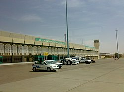
Al Ain Airport
| Al Ain International Airport | |
|---|---|

|
|
| Characteristics | |
| ICAO code | OMAL |
| IATA code | AAN |
| Coordinates | |
| Height above MSL | 265 m (869 ft ) |
| Transport links | |
| Distance from the city center | 13 km northwest of Al Ain |
| Street | Al Khaleej Al Arabi Street (146th St) or Al Ittihad Street (111th St) |
| Basic data | |
| opening | March 31, 1994 |
| operator | Abu Dhabi Airports Company |
| Start-and runway | |
| 01/19 | 4000 m × 45 m asphalt |
The airport al-Ain ( English Al Ain International Airport ; Arabic مطار العين الدولي) is the airport of the city of Al Ain in the United Arab Emirates .
location
The airport is located in the north-west of the city and is around 13 kilometers from the city center. The 960 bus, which has been in operation since the end of 2009, connects the airport via the city center with the Al Bawadi Mall at the southern end of the city every 30 minutes.
meaning
The civil part of the airport offers connections to:
In addition, there is a military base right next to the civilian part, where the Khalifa Bin Zayed (KBZ) Air College conducts basic and advanced training for the pilots of the United Arab Emirates Air Force .
Web links
- Airport data on World Aero Data ( 2006 )
Individual evidence
- ↑ AAN connections on flightstats
- ↑ Data on KBZ Air College ( memento of the original from October 13, 2010 in the Internet Archive ) Info: The archive link was automatically inserted and not yet checked. Please check the original and archive link according to the instructions and then remove this notice.