
Sao Tome Airport
| Sao Tome International Airport | |||
|---|---|---|---|
|
|||
| Characteristics | |||
| ICAO code | FPST | ||
| IATA code | TMS | ||
| Coordinates | |||
| Height above MSL | 10 m (33 ft ) | ||
| Transport links | |||
| Distance from the city center | 5 km northwest of São Tomé | ||
| Basic data | |||
| operator | Empresa Nacional de Aeroportos e Segurança Area | ||
| Start-and runway | |||
| 11/29 | 2220 m × 45 m asphalt | ||

The São Tomé International Airport is the civilian use airport of the island of São Tomé in the Gulf of Guinea off the coast of West Africa . The island is the main island of the state of São Tomé and Príncipe .
Airlines and destinations
- African Aviation (Libreville-Sao Tomé)
- Air Service Gabon (Libreville-Port Gentil)
- CEIBA International (Libreville, Malabo)
- STP Airways (Lisbon)
- TAAG Angola Airways (Luanda, Praia)
- TAP Portugal (Lisbon, Accra)

Sao Tome Airport

Airport
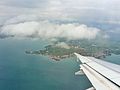
A bird's eye view of the airport
.jpg)
.jpg)
.jpg)
Incidents
- On July 29, 2017 at around 11:00 local time, the pilots of an Antonov An-74-TK-300 of Cavok Airlines with the aircraft registration UR-CKC had to abort the take-off from São Tomé Airport due to a bird strike. The aircraft could no longer be stopped on the runway, rolled down an embankment and came to a stop there. Five crew members suffered injuries. The aircraft was so badly damaged that it was no longer repaired.
Web links
Commons : São Tomé Airport - Collection of images, videos and audio files
- São Tomé e Príncipe website (en)
- Africa's Connection (en)
- Route map from Africa's Connection (Charter Airline) (en)