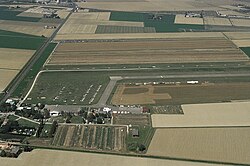
Ravenna Airport
| Ravenna Airport | |
|---|---|

|
|
| Characteristics | |
| ICAO code | LIDR |
| IATA code | RAN |
| Coordinates | |
| Height above MSL | 1 m (3 ft ) |
| Transport links | |
| Distance from the city center | 5 km south of Ravenna |
| Street | A14dir , SS16 , Via Dismano |
| Local transport | bus |
| Basic data | |
| opening | 1916 |
| operator | Aeroclub Ravenna |
| Start-and runway | |
| 08/26 | 1200 m × 30 m asphalt |
The Ravenna airport ( it: Aeroporto di Ravenna “Gastone Novelli” ) is located in the Italian region of Emilia-Romagna , around five kilometers south of the center of Ravenna .
Infrastructure and use
The airfield, which is located near the Adriatic coast , has a 1200-meter-long runway running in an east-west direction (08/26). A short taxiway connects the threshold 08 with the apron in the far southwest and its handling facilities. The airfield is used for general aviation . The operator is the local aero club, which also has a flight school here. In addition, still others are at the airfield Flying Clubs resident.
The airfield can be reached via the A14dir motorway and the SS16 state road . It is located on Via Dismano
history
The Ravenna airfield was opened as a military airfield in 1916 and later named after the fighter pilot Gastone Novelli, who was killed in an accident in 1919. Military use ended in the 1950s, whereupon the Aeroclub Ravenna took over the airfield and had the 1200 meter long asphalt runway built by 1962. Maintenance halls and other smaller facilities were also built. Over time, a number of air sports events were organized on site . A further expansion (to the commercial airport Ravennas) was not considered, as there are several other airfields and airports in the area, including the Forlì airport , which is about 25 kilometers south .
Web links
- Airport data on World Aero Data ( 2006 )
- Aeroclub Ravenna