Forbidden plateau
| Forbidden plateau | ||
|---|---|---|
| location | Vancouver Island | |
| Waters | Lake Helen Mackenzie Moat Lake |
|
| Mountains | Vancouver Island Ranges | |
| Geographical location | 49 ° 41 ′ 0 ″ N , 125 ° 19 ′ 0 ″ W | |
|
|
||
| height | 1000 to 1200 m | |
| surface | ~ 260 | |
| use | Provincial Park | |
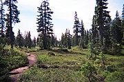
The Forbidden Plateau is a small, hilly plateau in the eastern part of the Vancouver Island Ranges in British Columbia . It is located northwest of Comox Lake roughly between Mount Albert Edward in the southwest and Mount Washington (location of the Mount Washington Alpine Resort) in the northeast. The plateau is predominantly in the Comox Valley Regional District .
On June 23, 1946 at 10:13 am ( PDT ), the epicenter of the Vancouver Island earthquake , which reached a magnitude of 7.3 and was the strongest reliably measured earthquake on the island to date, was below the Forbidden Plateau .
description
The gently sloping subalpine terrain is interrupted by small, rugged hills and is provided with small lakes. Many of them are located within Strathcona Provincial Park , and a network of trails makes hiking, cross-country skiing, and access to Mount Albert Edward easy. A subalpine meadow on Mount Beecher in the southwest corner of the plateau is the only place in Canada where the Olympic onion ( Allium crenulatum ), a species of leek , grows. The Forbidden Plateau was the epicenter of the Vancouver Island earthquake in 1946 , which was measured with 7.3 on the Richter magnitude scale , making it the strongest landquake ever recorded in Canada.
The legend
When the K'ómoks (better known as Comox ) spotted predators from other coastal tribes, they brought their wives and children to this plateau for their safety. Once, during a raid by the Cowichan , the women and children disappeared without a trace. When a member of the tribe tried to find the women and children on the Forbidden Plateau, he found red spots in the snow and on a nearby rock and he assumed that the blood had come from the family members. Since then, the plateau has been a taboo because it was believed that the plateau was inhabited by evil spirits who would devour those who had sent the women and children.
gallery
Web links
Individual evidence
- ^ Origin Notes and History. Forbidden plateau. GeoBC , accessed October 18, 2016 .
- ↑ The M7.3 Vancouver Island Earthquake of 1946. Natural Resources Canada , March 11, 2019, accessed August 25, 2020 .
- ^ Gary Schaan: Managing Towards the Gold Standard - Ecological Values of Second Growth Small Woodlands on Vancouver Island. In: TW Droscher, DA Fraser (Ed.): Proceedings of the 2003 Georgia Basin / Puget Sound Research Conference. 2004, OCLC 56828988 ( psat.wa.gov ( April 1, 2004 memento on the Internet Archive )).
- ↑ Derek Sidenius: Shake, Rattle and Roll in '46 Earthquake . Victoria Times Colonist Islander Magazine. January 24, 1999. Archived from the original on September 26, 2006. Retrieved July 14, 2006.
- ↑ Legends from British Columbia Communities ( Memento November 7, 2009 in the Internet Archive ) The British Columbia Folklore Society.
- ↑ Mark Yuasa: More to Nootka Sound than fishing. In: Seattle Times Newspaper. August 9, 2005, accessed October 19, 2016 .
- ↑ Michael Dawson: Selling British Columbia. Tourism and Consumer Culture, 1890-1970 . UBC Press, Vancouver 2004, ISBN 0-7748-1055-6 , pp. 164 .


