
Fort Buoux


The Fort Buoux is a ruined fortress in the area of southern French community Buoux . It is located on the northern edge of the Grand Luberon -Gebirges, where it holds a space surrounded by rocky peaks Molassesockel one.
Since 1986 the fort has been classified as a protected monument ( Monument historique ).
history
A fortification already existed at the site of the fort in prehistoric times. Later a Celtoligur oppidum and a Roman castrum emerged , from which the only passable pass over the Luberon was controlled. The medieval castle was built in the 13th century and was considered impregnable for a long time. The Huguenots used the castle as a place of retreat in the 16th century until Louis XIV had it torn down around 1660.
description
Access
The fort is located on an inaccessible rock ship that is approximately 500 m long and 30 to 100 m wide. The rock is composed of layers of sediment that were layered on top of each other by marine deposits over a period of 20 million years.
The path leading to the fort follows an old antique road that runs under a huge rock overhang ( abri ). In the Neolithic , the rocks were provided with various cavities that served as storage pits and burial sites. The path carved into the rock leads to a first bastion and an arched entrance gate guarded by it .
Fortress square and medieval village
The fortress square was protected by a fortification wall that formed the first line of defense for the castrum . On the square there is a 60,000 liter, formerly vaulted water reservoir and a defensive trench that should hold back potential attackers.
The protective walls of a medieval village, made up of storehouses, scattered walls and cave dwellings , stand parallel to the site . In a landmark building dating from the 13th century with one of voussoirs formed circular portal equipped. In front of the fortress, on a rocky, formerly covered area, one comes across thirteen silos carved in stone and traces of a wine press .
The fortress

The fortress was built as a spur castle in the 13th century . It is particularly well adapted to the topographical conditions and was provided with three fortification walls, each protected by ditches. In the first wall, which is equipped with a raised gate, closely spaced arches are embedded. The second protective wall is very high and has been reinforced with a square tower. The third wall finally takes the place on the two vertical cliffs.
The donjon , originally built on three levels, looks down on an abyss up to 80 m deep. The exit gate is at the bottom of the grain silos and leads to a secret staircase, the role of which is still unclear. It could have been an important part of the defense system or it could have had a cultural function in early history .
gallery
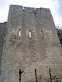
Tower with arch loops

Inside of the donjon

Stone silos

Watchtower


See also
literature
- Michel Albarède et al .: Vaucluse (= Encyclopédies du Voyage ). Gallimard Loisirs, Paris 2007, ISBN 2-7424-1900-4 , p. 274-275 .
- Cony Ziegler: Provence with Camargue. Travel book publisher Iwanowski. 2nd updated edition. Dormagen 2009, ISBN 978-3-933041-54-8 , p. 332.
- Ines Mache, Stefan Brandenburg: Provence. 7th revised and completely updated edition. Reise Know-How Verlag Rump, Bielefeld 2011, ISBN 978-3-8317-2022-4 , pp. 482-483.
Web links
Individual evidence
- ↑ Entry no. PA00081985 in the Base Mérimée of the French Ministry of Culture (French)
- ^ A b Cony Ziegler: Provence with Camargue. 2009, p. 332.
- ↑ a b c Michel Albarède et al .: Vaucluse. 2007, p. 274.
- ↑ a b Michel Albarède et al .: Vaucluse. 2007, p. 275.
Coordinates: 43 ° 49 ′ 5 ″ N , 5 ° 22 ′ 46 ″ E