Buoux
| Buoux | ||
|---|---|---|

|
|
|
| region | Provence-Alpes-Cote d'Azur | |
| Department | Vaucluse | |
| Arrondissement | Apt | |
| Canton | Apt | |
| Community association | Pays d'Apt-Luberon | |
| Coordinates | 43 ° 50 ' N , 5 ° 23' E | |
| height | 253-902 m | |
| surface | 17.54 km 2 | |
| Residents | 68 (January 1, 2017) | |
| Population density | 4 inhabitants / km 2 | |
| Post Code | 84480 | |
| INSEE code | 84023 | |
| Website | buoux-village.com | |
 Buoux village |
||
Buoux is a French municipality with 68 inhabitants (at January 1, 2017) in the Vaucluse department in the region of Provence-Alpes-Cote d'Azur .
geography
Buoux is five kilometers south of the city of Apt . Other neighboring communities are Bonnieux , Lourmarin , Vaugines , Sivergues and Saignon .
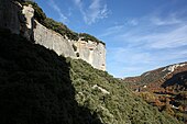
The municipality is located in the center of the Luberon Regional Nature Park on the Claparèdes plateau , which stretches between the northern flank of the Cretaceous Luberon Mountains and the Calavon valley, which was formed in the Tertiary . The Aigue Brun - the only permanently water-bearing river in the Luberon - flows right through the municipality . It serves as the sole drain of the Claparèdes and has dug a ravine to the Durance in the south between the Grand and Petit Luberon . At its upper reaches, in the Buoux area, the river valley is bordered by high rock walls and scattered individual rock peaks, which are particularly interesting for climbers . The high, rugged rock faces have a damp, cool climate and offer a flora that is unique in Provence and that is otherwise only found in temperate or cold regions.
traffic
The route départementale D11 runs through the town of Buoux .
history
The first traces of human presence go back to the Moustérien age 70,000 years ago. The caves in the valley of the Aigue Brun, especially the trees of the Peyrard , were used by the Neanderthals as preferred settlement places for several millennia .
Near the village of Moulin Clos are the ruins of a first village, Saint-Germain , inhabited in the fifth century but abandoned in favor of the fortress between the 12th and 14th centuries. The current village of Buoux came into being at the end of the 17th century.
Population development
| year | 1962 | 1968 | 1975 | 1982 | 1990 | 1999 | 2006 |
|---|---|---|---|---|---|---|---|
| Residents | 44 | 44 | 72 | 103 | 118 | 112 | 122 |
Attractions

Twenty minutes' walk northwest of the village is the cemetery with the Romanesque Ste-Marie chapel from the 13th century.
Only ruins remain of Fort Buoux , which is located on a rocky promontory . Louis XIV had the fortress demolished, fearing that it could serve as a refuge for Huguenots . In addition to the fortress walls, you can still see the remains of cisterns and silos carved into the rock . The fort also offers a beautiful view of the surrounding valley.
The Buoux Castle is part of the Luberon Regional Park and is also called Château de l'Environnement ("Castle of the Environment"). It is mainly open to school classes and houses a protection center for wild animals.
literature
- Michel Albarède et al .: Vaucluse (= Encyclopédies du Voyage ). Gallimard Loisirs, Paris 2007, ISBN 2-7424-1900-4 , p. 273-275 .
- Marie-Christine Mansuy et al .: Parc Naturel Régional du Luberon (= Encyclopédies du Voyage ). Gallimard Loisirs, Paris 2010, ISBN 978-2-7424-2737-6 , pp. 96-97 .
Web links
- Official website (French)
Individual evidence
- ↑ The community on annuaire-mairie.fr
- ↑ a b c Michel Albarède et al .: Vaucluse. 2007, p. 273.
- ^ A b Marie-Christine Mansuy et al .: Parc Naturel Régional du Luberon. 2010, p. 96.
- ^ Marie-Christine Mansuy et al .: Parc Naturel Régional du Luberon. 2010, pp. 96-97.
- ^ Marie-Christine Mansuy et al .: Parc Naturel Régional du Luberon. 2010, p. 97.


