
Murs (Vaucluse)
| Murs | ||
|---|---|---|
.svg)
|
|
|
| region | Provence-Alpes-Cote d'Azur | |
| Department | Vaucluse | |
| Arrondissement | Apt | |
| Canton | Apt | |
| Community association | Pays d'Apt-Luberon | |
| Coordinates | 43 ° 57 ' N , 5 ° 14' E | |
| height | 240-805 m | |
| surface | 31.27 km 2 | |
| Residents | 419 (January 1, 2017) | |
| Population density | 13 inhabitants / km 2 | |
| Post Code | 84220 | |
| INSEE code | 84085 | |
 Place view |
||

Murs [myːʀs] ( Murs en Provence ) is a French municipality with 419 inhabitants (at January 1, 2017) in the department of Vaucluse in the region Provence-Alpes-Cote d'Azur .
geography
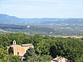
The village is located on the slopes of the Monts de Vaucluse at the crossroads of the roads from Gordes to Sault and Venasque and Apt . The town center is located at an average height of 500 m above sea level.
Murs is eight kilometers from Gordes and 17 kilometers from Apt and is part of the Luberon Regional Natural Park . It also belongs to the Côtes du Ventoux wine-growing region , whose designation of origin is protected by the Appellation d'Origine Contrôlée (AOC).
Neighboring municipalities are (clockwise from the east): Lioux , Joucas , Gordes , Venasque and Methamis .
Population development
| year | 1962 | 1968 | 1975 | 1982 | 1990 | 1999 | 2007 | 2012 |
| Residents | 263 | 277 | 306 | 334 | 391 | 415 | 425 | 410 |
Attractions
- The late medieval castle mostly from the 15th century (today in private ownership)
- The 12th century Romanesque church of Saint-Loup
- The Notre-Dame du Salut chapel from 1625
- The house in which King Henry IV's general , Louis des Balbes de Berton de Crillon (1541–1615), also called Crillon , was born in the 13th century
- Remains of the plague wall from 1721
- Moulins de la Véroncle (example of hydropower use from the 15th to 19th centuries)
- The caves Grottes de Bérigoule
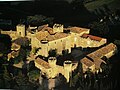
Castle

Romanesque church
Notre-Dame du Salut chapel

Birth house of Louis de Balbes de Berton de Crillon


