
Rustrel
| Rustrel | ||
|---|---|---|
.svg)
|
|
|
| region | Provence-Alpes-Cote d'Azur | |
| Department | Vaucluse | |
| Arrondissement | Apt | |
| Canton | Apt | |
| Community association | Pays d'Apt-Luberon | |
| Coordinates | 43 ° 55 ' N , 5 ° 29' E | |
| height | 279–1,073 m | |
| surface | 28.26 km 2 | |
| Residents | 688 (January 1, 2017) | |
| Population density | 24 inhabitants / km 2 | |
| Post Code | 84400 | |
| INSEE code | 84103 | |
| Website | http://www.rustrel.fr/ | |

Rustrel is a french commune in the department of Vaucluse in the region Provence-Alpes-Cote d'Azur . It belongs to the canton of Apt in the Apt arrondissement . The place has 688 inhabitants (as of January 1, 2017) and an area of 28 km².
geography
The village is at the foot of two hills, near the town of Apt , on the banks of the River Coulon . The municipality is part of the Luberon Regional Nature Park . Its different colored ocher rocks are known. In some places, ocher is still mined to produce natural colors for the arts and crafts.
history
The first traces of settlement can be found from the Neolithic Age . Numerous traces can be found from the time of the Roman Empire . The village is mentioned in writing as Rograstrel in the 12th century , then in 1274 as Ruastrello .
During the Wars of Religion, the village was occupied by the Huguenots from 1570 to 1575 .
Attractions
In addition to the main attraction, the ocher cliffs in the village and the surrounding area, there is a church from the 16th century and a castle from the 17th century , which today houses the municipal administration. A small museum is housed in an oil mill from the 18th century .
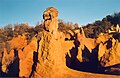
Ocher rocks near Rustrel

Colorado Rustrel

Colorado Rustrel
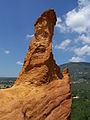
Colorado Rustrel


