Vaugines
| Vaugines | ||
|---|---|---|

|
|
|
| region | Provence-Alpes-Cote d'Azur | |
| Department | Vaucluse | |
| Arrondissement | Apt | |
| Canton | Cheval-Blanc | |
| Community association | Luberon Monts de Vaucluse | |
| Coordinates | 43 ° 47 ' N , 5 ° 25' E | |
| height | 211-902 m | |
| surface | 15.55 km 2 | |
| Residents | 568 (January 1, 2017) | |
| Population density | 37 inhabitants / km 2 | |
| Post Code | 84160 | |
| INSEE code | 84140 | |
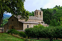
 Vaugines village |
||
Vaugines is a French municipality with 568 inhabitants (at January 1, 2017) in the department of Vaucluse in the region Provence-Alpes-Cote d'Azur . It belongs to the canton of Cheval-Blanc in the Apt arrondissement .
geography
Vaugines is located in the southeast of the Vaucluse department and borders the municipalities of Lourmarin , Cadenet , Ansouis , Cucuron , Sivergues and Buoux . The closest towns are Apt in the north ( 11 km ) and Pertuis in the southeast ( 12 km ).
The place is surrounded by vineyards , small oak forests and olive groves . In the north of the municipality, the steep southern slope of the Grand Luberon rises with the Luberon Regional Nature Park , to which the municipality does not belong. The Laval stream flows west of the town center and flows into the Durance at Cadenet .
traffic
The village of Vaugines can be reached via the départementale D56 route, which passes the community south of the village center on a west-east axis. The D45 branches off from this in the south and continues to Cadenet. Coming from Lourmarin, the D27 continues through the southern municipality towards Cucuron.
history
The foundation of Vaugines goes back to the common will of the Benedictines of Psalmodie and the Baron von Ansouis, who built a church and a castle on the ruins of the St-Saveur monastery in the 13th century. The village was abandoned at the beginning of the 15th century and repopulated in 1474. In the 18th century, a cave settlement was built on the Poucelles rock in what is now the Quartier des Grottes .
Population development
| year | 1962 | 1968 | 1975 | 1982 | 1990 | 1999 | 2006 |
|---|---|---|---|---|---|---|---|
| Residents | 245 | 225 | 216 | 253 | 325 | 466 | 558 |
Attractions
The town hall square was created in the 19th century as part of a redesign of the center and was intended to serve as a connection between the two previously separate districts. Many new public buildings and shops have been built around the square. The Mairie , surmounted by a bell tower, replaced the former parish hall in 1845 .
The commandery on rue des Amazones is housed in an enlarged medieval building. The former townhouse Hôtel des Bouliers was owned by the Bouliers family, which included the prior of Vaugines in the 16th century . The Capitainerie was built in the 16th century by Antoine Bouchard, known as the Capitaine de Vaugines . The solid house with cross- frame windows is located near the former parish hall from the 18th century.
The St-Barthélémy church, built on the remains of a monastery, is located outside the village center and dates mostly to the 13th century. It served as the setting for the film Jean Florette , which was directed by Claude Berri based on a novel by Marcel Pagnol .
Others
An old path leads from the municipality to the Luberon, which is mentioned in the novel L'Habitant de Sivergue by Henri Bosco .
literature
- Michel Albarède u. a .: Vaucluse (= Encyclopédies du Voyage ). Gallimard Loisirs, Paris 2007, ISBN 2-7424-1900-4 , p. 288 .
- Marie-Christine Mansuy u. a .: Parc Naturel Régional du Luberon (= Encyclopédies du Voyage ). Gallimard Loisirs, Paris 2010, ISBN 978-2-7424-2737-6 , pp. 127-128 .


