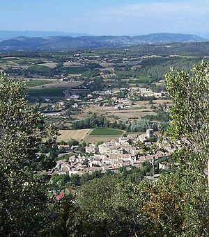
Beaumont-de-Pertuis
| Beaumont-de-Pertuis | ||
|---|---|---|

|
|
|
| region | Provence-Alpes-Cote d'Azur | |
| Department | Vaucluse | |
| Arrondissement | Apt | |
| Canton | Pertuis | |
| Community association | Territorial South Luberon | |
| Coordinates | 43 ° 44 ' N , 5 ° 41' E | |
| height | 230-602 m | |
| surface | 56.07 km 2 | |
| Residents | 1,137 (January 1, 2017) | |
| Population density | 20 inhabitants / km 2 | |
| Post Code | 84120 | |
| INSEE code | 84014 | |
 View from the Sainte-Croix mountain |
||
Beaumont-de-Pertuis is a French commune with 1,137 inhabitants (at January 1, 2017) in the Vaucluse department in the region of Provence-Alpes-Cote d'Azur . It belongs to the canton of Pertuis in the Apt arrondissement .
geography
Beaumont-de-Pertuis is the easternmost municipality in the Vaucluse department. It is located about 13 kilometers southwest of Manosque and 15 kilometers northeast of Pertuis . Neighboring municipalities in Vaucluse are La Bastide-des-Jourdans in the north-west, Grambois in the west and Mirabeau in the south-west. The Durance in the southeast forms the natural border with Saint-Paul-lès-Durance in the Bouches-du-Rhône department and Vinon-sur-Verdon in the Var department . In the north-east and north are the municipalities of Corbières-en-Provence and Pierrevert of the Alpes-de-Haute-Provence department .
With an area of 56.07 km² , Beaumont-de-Pertuis is one of the largest municipalities in the department. In the northwest rise the foothills of the Grand Luberon with the Luberon Regional Park , to which the municipality belongs. The Torrent de Saint-Marcel, which flows past the town center, has its source at around 480 meters above the border in the area of La Bastide-des-Jourdans and, after 11.2 kilometers, flows into the Durance as a right tributary.
traffic
In the very south-east of the municipality, the A51 autoroute runs from Marseille and Aix-en-Provence , but there is no connection from Beaumont. The départementale D996 route, which runs parallel to this, connects the cities of Pertuis and Manosque, where the nearest train stations are also located.
history
The first traces of human presence go back to prehistoric times . In the Middle Ages , the city was on a busy trade route and had more than 1000 inhabitants. This made it one of the largest and most densely populated places in the area. Beaumont-de-Pertuis has been struck by five earthquakes since 1509 , of which the most severe to date has been the one in 1812, with a magnitude of 7 to 8. Its traces can still be seen through cracks on many public monuments such as B. the church of St-Jean-Baptiste visible.
Population development
| year | 1962 | 1968 | 1975 | 1982 | 1990 | 1999 | 2006 | 2017 |
|---|---|---|---|---|---|---|---|---|
| Residents | 492 | 631 | 601 | 658 | 788 | 934 | 1001 | 1137 |
Attractions

- Prehistoric dwellings in the rock caves of Saint-Eucher
- Oppidum Montmartre
- Remains of an elliptical walling with three round towers (16th century)
- Former windmill near Hautes-Croix
- Watermill (late 18th century)
- Parish Church of St-Jean-Baptiste
- St-Eucher rock chapel (12th century)
- Notre-Dame-de-Beauvoir chapel with statue of St. Eucher
- Romanesque chapel Ste-Croix
literature
- Michel Albarède u. a .: Vaucluse (= Encyclopédies du Voyage ). Gallimard Loisirs, Paris 2007, ISBN 2-7424-1900-4 , p. 302 .
- Marie-Christine Mansuy among others: Parc Naturel Régional du Luberon (= Encyclopédies du Voyage ). Gallimard Loisirs, Paris 2010, ISBN 978-2-7424-2737-6 , pp. 133-134 .
Web links
Individual evidence
- ↑ a b c The community on annuaire-mairie.fr
- ↑ Torrent de Saint-Marcel at SANDRE (French)
- ↑ History of Beaumont on paysdaigues.fr. (No longer available online.) Archived from the original on December 7, 2014 ; Retrieved October 27, 2012 .
