
Goult
| Goult | ||
|---|---|---|
.svg)
|
|
|
| region | Provence-Alpes-Cote d'Azur | |
| Department | Vaucluse | |
| Arrondissement | Apt | |
| Canton | Apt | |
| Community association | Pays d'Apt-Luberon | |
| Coordinates | 43 ° 52 ' N , 5 ° 15' E | |
| height | 121-335 m | |
| surface | 23.77 km 2 | |
| Residents | 1,099 (January 1, 2017) | |
| Population density | 46 inhabitants / km 2 | |
| Post Code | 84220 | |
| INSEE code | 84051 | |
| Website | http://www.goult.fr/ | |
 Goult market |
||

Goult is a french commune with 1,099 inhabitants (at January 1, 2017) in the department of Vaucluse in the region Provence-Alpes-Cote d'Azur . The community is a member of the 2014 newly created municipal association Communauté de communes Pays d'Apt-Luberon .
geography
The Coulon flows through Goult . The D900 departmental road runs north of the water . The neighboring communities are
- Roussillon in the northeast,
- Bonnieux in the southeast,
- Lacoste and Ménerbes in the south,
- Beaumettes in the southwest,
- Saint-Pantaléon and Gordes to the north-west.
The commune belongs to the Côtes du Ventoux wine-growing region , whose designation of origin is protected by the Appellation d'Origine Contrôlée (AOC).
Population development
| year | 1962 | 1968 | 1975 | 1982 | 1990 | 1999 | 2008 |
|---|---|---|---|---|---|---|---|
| Residents | 898 | 945 | 1,051 | 1.109 | 1,281 | 1,285 | 1,176 |
Attractions
The Dolmen de l'Ubac is on the edge of the Marican plain, near the Ubac hills, on the left bank of Le Calavon, southwest of Goult.
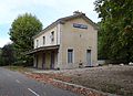
The former Goult-Lumieres station
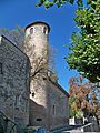
Goult Castle

Dolmen de l'Ubac

The Saint-Sébastien church
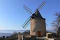
The "Moulin de Jérusalem" windmill


