
Coulon (river)
|
Coulon Calavon |
||
 The river at Beaumettes |
||
| Data | ||
| Water code | FR : X34-0400 | |
| location | France , Provence-Alpes-Cote d'Azur region | |
| River system | Rhône | |
| Drain over | Durance → Rhône → Mediterranean | |
| source | in the parish of Banon, 44 ° 2 ′ 31 ″ N , 5 ° 38 ′ 19 ″ E |
|
| Source height | approx. 740 m | |
| muzzle | Northwest of Cavaillon in the Durance Coordinates: 43 ° 51 ′ 21 " N , 4 ° 59 ′ 13" E, 43 ° 51 ′ 21 " N , 4 ° 59 ′ 13" E |
|
| Mouth height | approx. 55 m | |
| Height difference | approx. 685 m | |
| Bottom slope | approx. 7.9 ‰ | |
| length | approx. 87 km | |
| Right tributaries | Riaille | |
| Medium-sized cities | Cavaillon | |
| Small towns | Apt | |
The Coulon , in the upper half of its course, the Calavon , is a river in France that runs in the Provence-Alpes-Côte d'Azur region . It rises in the municipality of Banon , initially drains in a southerly direction, then swings in to the west and flows into the Durance as a right tributary after a total of around 87 kilometers northwest of Cavaillon . On its way, the Coulon crosses the Alpes-de-Haute-Provence and Vaucluse departments as well as the Luberon Regional Nature Park .
Hydrology
The water flow changes again and again between periods of drought and normal water flow. Flood situations are hardly predictable and often have catastrophic effects, as most recently in December 2008. In the years around 1980 it gained a certain fame because it was called "the most polluted river in France" because it was caused by the sewage from the factories in the city of Apt , famous for the production of candied fruit, became a black, smelly sewer. Its condition has improved considerably to this day, thanks to the media coverage of Hans Silvester and the actions of the Luberon Regional Nature Park, investments were made in water treatment and the improvement of the water quality of the river and its tributaries.
Tributaries

- Downstream sequence -
- right after 9 km: Riaille (20.7 km, X3400500 )
- left: Aiguebelle (Calavon) (3.1 km, SANDRE X3410520 )
- left: Grand Vallat (Calavon) (8.3 SANDRE X3410700 )
- left: Encrême (10.5 km, SANDRE X3420520 )
- right: Dôa (15.9 km, SANDRE X3440500 )
- right: Riaille (Apt) (7.8 km, SANDRE X3450540 )
- right: Urbane (river) (8.7 km, SANDRE X3460500 )
- left: Raille (left inflow) (5.3 km, SANDRE X3460680 )
- right: Imergue (16.8 km, SANDRE X3470500 )
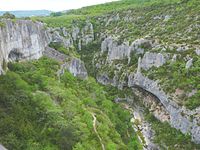
Calavon gorge near Oppedette

Places on the river
- Downstream sequence -
Attractions
- Imposing gorges Gorges d'Oppedette south of Oppedette
- Roman bridge Pont Julien over the Coulon