Fort Sill
| Fort Sill | ||
|---|---|---|
| National Register of Historic Places | ||
| Historic District | ||
| National Historic Landmark | ||
|
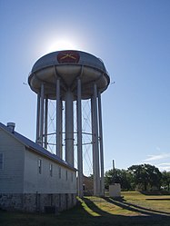
Water tower of Fort Sill |
||
|
|
||
| location | Comanche County , Oklahoma | |
| Coordinates | 34 ° 39 ′ 7 ″ N , 98 ° 24 ′ 17 ″ W | |
| Built | 1869 | |
| NRHP number | 66000629 | |
| The NRHP added | October 15, 1966 | |
| Declared as an NHL | December 19, 1960 | |
Fort Sill is a military base of the US Army . It is located in the state of Oklahoma , about 135 km southwest of Oklahoma City . Fort Sill is the last of the forts built on the southern prairie during the Indian Wars that is still actively used by the Army. The fort was founded on January 8, 1869 by Maj. Gen. Philip Sheridan and named after his friend, Brigadier General Joshua W. Sill , who died in the Battle of the Stones River in the Civil War . In 2008 a good 20,000 soldiers were stationed in Fort Sill.
Today, the United States Army Field Artillery School and the Air Defense Artillery School , relocated from Fort Bliss in 2011, are located in Fort Sill.
At the time of nuclear armament ( Soviet SS-20 and US Pershing ) Fort Sill was used for the appropriate training of soldiers of the German Armed Forces .
The fort has been a National Historic Landmark since December 1960 . In October 1966, it was listed as a Historic District on the National Register of Historic Places .
Stationed units
- United States Army Field Artillery School
- 75th Artillery Brigade
- 428th Artillery Brigade
- Air Defense Artillery School
- 31st Air Defense Brigade
People born here
- Allan Houser (1914–1994), painter and sculptor
- Elizabeth Scott (1917–1988), mathematician
- Gene Casey (1933-2003), jazz pianist
- Mary Pope Osborne (* 1949), children's book author
- Tom Platz (* 1955), bodybuilder
- Conrad Herwig (* 1959), jazz trombonist
- Stephen Hillenburg (1961–2018), inventor of the cartoon character SpongeBob SquarePants
- Joseph R. Mendelson (* 1964), herpetologist
- John Godina (* 1972), shot putter and discus thrower
Web links
- Fort Sill website (English)
- Fort Sill at globalsecurity.org (English)
Individual evidence
- ↑ Listing of National Historic Landmarks by State: Oklahoma. National Park Service , accessed February 7, 2020.
- ^ Fort Sill in the National Register Information System. National Park Service , accessed February 7, 2020.


