Four Corners Monument
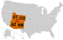
The Four Corners Monument is a monument on the Four Corners [ fɔː ˈkɔːnəz ] (German four corners ). It was erected at the point where the four US states of Utah , Colorado , New Mexico and Arizona meet (clockwise, starting in the northwest). This is the only quadrangle of states in the United States . It is located on the Colorado Plateau and belongs to the Navajo Nation , the self-governing territory of the Navajo .
Since the middle of the 19th century, there have been repeated border changes in the areas adjacent to one another at this point. It became a four-way boundary in 1863 when the newly formed Arizona Territory was separated from the New Mexico Territory . At its northern end, the border between New Mexico and Arizona met the already existing border between the Utah and Colorado territories , which ran along the same meridian . (The four territories only became states later.)
history
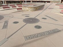
In 1875 the border point was first marketed by a sandstone pillar; this was replaced by a new stone in 1899. In 1912 a simple cement slab was poured around the boundary stone. In 1931 the point was marked by a brass disc embedded in cement. In 1992 the monument was redesigned from the ground up: since then it has consisted of a square stone platform with a round granite slab in the middle, in the center of which the US Department of the Interior placed a newly designed aluminum-bronze border marker. In 2010 the monument was renewed again, whereby the pane in the middle was not changed.
The granite slab bears the inscription
- Here meet in freedom under God four states
(German: Here four states meet in freedom under God ). The lettering is arranged in a circle, with two words in each of the four sectors. Depending on the starting point, there are three further reading options: In freedom under God four states here meet / Under God four states here meet in freedom / Four states here meet in freedom under God . The coats of arms of the respective states are placed around the granite slab in the individual sectors.
Despite its remote location, the point has grown into a tourist hub operated by the Navajo Parks and Recreation Department . Around the monument, Navajo and Ute artists sell souvenirs and snacks.
In the area around Four Corners a daunting was satellite data methane emissions from nearby coal discovered mining sites. At an estimated 600,000 tonnes per year, emissions are greater than those of the entire UK oil, gas and coal industry.
See also
Web links
Individual evidence
- ↑ Field Notes of the Remonumentation of the Corner Common to the State of Colorado, New Mexico, Arizona and Utah. ( Memento of the original from December 24, 2013 in the Internet Archive ) Info: The archive link was inserted automatically and has not yet been checked. Please check the original and archive link according to the instructions and then remove this notice. Bureau of Land Management, 1992, accessed December 22, 2013
- ^ Arizona Highways, Volume 39. Arizona Highways Department, 1963
- ↑ mbe: Satellite image of the week: Huge methane leak discovered in the USA. In: SPIEGEL.de. October 11, 2014, accessed October 11, 2014 .
Coordinates: 36 ° 59'56.4 " N , 109 ° 2'43.1" W.


