Freycinet Peninsula
| Freycinet Peninsula | ||
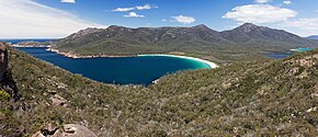
 Wineglass Bay on the Freycinet Peninsula |
||
| Geographical location | ||
|
|
||
| Coordinates | 42 ° 13 ′ S , 148 ° 18 ′ E | |
| Waters 1 | Tasman Sea | |
| length | 23 km | |
| width | 6.5 km | |
| surface | 65 km² | |
The Freycinet Peninsula is located on the east coast of the Australian state of Tasmania , and protrudes south into the Tasman Sea . The peninsula is connected to the mainland (the island of Tasmania) via narrow sandbanks .
The peninsula is about 23 km long and up to 6.5 km wide. It has a land area of around 65 km² and rises up to 613 m above sea level. Immediately in front of it to the south is the small Schouten Island .
The Freycinet Peninsula , together with the Schouten Island, forms the main area of the Freycinet National Park, founded in 1916 . The peninsula and national park owe their name to the French navigator Louis de Freycinet (1779–1842).
Web links
- Information about the National Park ( Memento from September 29, 2007 in the Internet Archive )
