
Freycinet National Park
| Freycinet National Park | |||
|---|---|---|---|
 |
|||
|
|||
| Location: | Tasmania , Australia | ||
| Specialty: | Wineglass Bay | ||
| Next city: | Coles Bay , Swansea | ||
| Surface: | 168 km² | ||
| Founding: | 1916 | ||
| Visitors: | 200,000 (2008) | ||
| Address: |
Freycinet National Park Freycinet National Park Office Private Bag Bicheno TAS 7215 |
||
|
|
|||

The Freycinet National Park ( English Freycinet National Park ) is a national park on the east coast of the Australian state of Tasmania . In addition to the rugged granite formations, it is known above all for Wineglass Bay .
geography
The park is mainly located on the Freycinet Peninsula on the northeast coast of Tasmania, but also includes parts of the coast a little further north and the island of Schouten at the southern tip of the peninsula . The closest village is Coles Bay , the nearest major town to Swansea .
geology
The predominant rock type is granite from the Devonian , orthoclase and feldspar give it a characteristic pink tint. The west side of the island of Schouten consists of Jurassic dolerite .
history
In 1642, Abel Tasman sailed along the Tasmanian east coast and named the island Schouten after a director of the Dutch East India Company . The Freycinet Peninsula is named after the French navigator Louis de Freycinet who explored Vandiemensland (today's Tasmania) under the command of Nicholas Baudin in 1802/03 . The first years of European settlement history in the area of today's national park and the Great Oyster Bay were mainly characterized by whaling and tin and coal mining .
The national park was established on August 29, 1916 and is together with Mount Field National Park the oldest national park in Tasmania. Today tourism is by far the most important source of income.
Flora and fauna
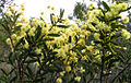
blooming acacia bush
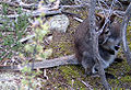
Bennett's wallaby
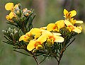
Spring in Freycinet National Park


See also
Web links
- Further information and photo gallery ( Memento from September 29, 2007 in the Internet Archive )
- Tasmanian Parks and Wildlife Service
Individual evidence
A Asbestos Range | B Ben Lomond | C Cradle Mountain-Lake St Clair | D Douglas Apsley | F Franklin Gordon Wild Rivers | Freycinet | H Hartz Mountains | K Kent Group | L Lake Pedder | M Maria Island | Mole Creek Karst | Mount Field | Mount William | N Narawntapu | R Rocky Cape | S Savage River | South Bruny | Southwest | Strzelecki | T Tasman | W Walls of Jerusalem