Maria Island
| Maria Island | ||
|---|---|---|
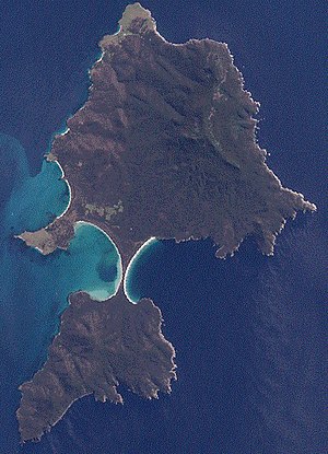
| NASA satellite image of Maria Island | ||
| Waters | Tasman Sea | |
| Geographical location | 42 ° 39 ′ S , 148 ° 6 ′ E | |
|
|
||
| length | 20 km | |
| width | 13 km | |
| surface | 115.5 km² | |
| Highest elevation | Mount Maria 709 m |
|
| Residents | uninhabited | |
| Map of the island | ||
Maria Island is an island off the east coast of the Australian island of Tasmania .
geography
The island is almost divided into two parts by two sickle-shaped bays. A headland, at its thinnest point about 200 meters wide, connects the much larger northern part with the southern part of the island. The highest point is Mount Maria at 709 meters.
About 500 meters from the north coast is the small island of Ile du Nord .
history
Long before European explorers came to this region of the world, Aborigines from the Tyreddeme tribe settled the island. The explorer Abel Tasman named the island in 1642 after Maria van Diemen, wife of the governor general of the Dutch East Indies, Anton van Diemen . The French explorer Nicolas Baudin was one of the first Europeans to set foot on the island.
Maria Island was settled by whale and seal hunters in the early 19th century and was used as a penal colony by the English from 1825 to 1832. The Italian entrepreneur Diego Bernacchi leased the island for some time in 1884, had a cement factory built and tried to grow wine. He founded a settlement with at times up to 250 inhabitants, a school, post office and shops. The company failed in 1892. Only the cement factory was not enough and Bernacchi returned to London via Melbourne in 1886 . In 1925 he tried a second time. However, his ideas, including those of tourism, were ahead of his time and in 1930 he finally failed. After this second period of industrialization, Maria Island was settled by a few farming families. Some ruins of former farmhouses on the island also date from this time. The end came in 1971 when the Tasmanian government started buying up the land and turning it into a national park.
Today the island is no longer permanently inhabited and is usually only home to a small group of rangers and tourists in the summer months.
Flora and fauna

An enormous number of Forester kangaroos , wallabies , filanders (English pademelon), Cape barren geese, ant urchins and wombats populate the island. All the grass on the island has been eaten up to the scar by the animals. The mostly crepuscular animals are hardly shy of humans and sometimes come very close to humans on their own. Otherwise, the island is also inhabited by a variety of bird species, all three species of snakes found in Tasmania and a few other animal species. On Maria Island there is also the Tasmanian barn owl , which is the largest of all barn owls with a height of up to 55 centimeters .
Sightseeing and tourism
The easiest way to get to the island is by ferry. A speedboat runs twice a day between Triabunna on Tasmania and Darlington on Maria Island. In Triabunna you can also get the necessary visitor ID. No motorized vehicles are allowed on the island itself. However, bicycles are allowed. There is neither electricity nor a shop on the island. Hot water is only available in limited quantities with shower coins. Every tourist must therefore bring everything they need with them in sufficient quantities.
Darlington
The former settlement of Darlington is located in the northwest of the island. There is a small jetty in Darlington Bay. The extremely unsightly four cement towers are clearly visible here, a monument to the attempted industrialization. Despite attempts to blast them, they are now a listed building.
The former convict camp in Darlington, the Darlington Probation Station , was recognized as a World Heritage Site by UNESCO in 2010 . It was the second camp of its kind in Tasmania and is now used as a ranger station and accommodation in six-bed rooms with wood-burning stoves. Directly behind the partly restored and partly dilapidated buildings is a small campsite for individual tourists.
A little to the north of the jetty there is a 500-meter-short runway (category ALA, Airplane Landing Area) for small aircraft. The flight time to Hobart is around 20 minutes.
Painted Cliffs
The Painted Cliffs are located about two kilometers south of the jetty. They are for sure one of the highlights of the island. Iron-containing water has given the formerly white limestone a reddish to yellowish color. The rocks themselves are now washed away by the sea and can only be viewed without problems at low tide.
Fossil Cliffs
In Fossil Bay, on the north coast of Maria Island, there are large blocks of stone and rock walls that are littered with thousands upon thousands of petrified shells and sea snails, the Fossil Cliffs. At low tide there is a good way to get to the fossils that are millions of years old.
Mount Bishop & Clerk
A half-day hike can be used to reach the top of Mount Bishop & Clerk, which is around 600 meters high. The rock drops steeply towards the coast and you can see almost the entire island.
National park
In 1971/1972 parts of the island and marine areas in front of the island were declared a national park.
See also
Web links
- official site of the park (Engl.)
- Article about Maria Iceland on theage.com.au (Engl.)
- Information site Tourism Tasmania (Engl.)


