Žulová
| Žulová | ||||
|---|---|---|---|---|
|
||||
| Basic data | ||||
| State : |
|
|||
| Region : | Olomoucký kraj | |||
| District : | Jeseník | |||
| Area : | 1475 ha | |||
| Geographic location : | 50 ° 19 ' N , 17 ° 6' E | |||
| Height: | 290 m nm | |||
| Residents : | 1,247 (Jan 1, 2019) | |||
| Postal code : | 790 65 | |||
| License plate : | M. | |||
| traffic | ||||
| Street: | Jeseník - Javorník | |||
| Railway connection: | Lipová-lázně – Bernartice u Javorníka | |||
| structure | ||||
| Status: | city | |||
| Districts: | 2 | |||
| administration | ||||
| Mayor : | Radek Trsťan (as of 2018) | |||
| Address: | Hlavní 36 790 65 Žulová |
|||
| Municipality number: | 541575 | |||
| Website : | www.mestozulova.cz | |||
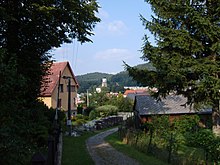
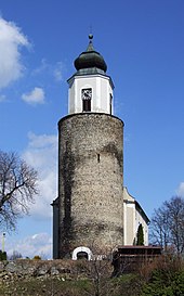
Žulová , until 1948 Frýdberk (German Friedeberg ), is a town in the Czech town of Okres Jeseník ( Freiwaldau district ). The site is the St. Joseph Church, where the dungeon is the old castle Frýdberk as a steeple, and coined the God Mountain with the Sanctuary.
Geographical location
The city is located in the Sudetes , about twelve kilometers northwest of Freiwaldau ( Jeseník ) and 81 kilometers north of the city of Olomouc at the confluence of the Stříbrný potok ( Schlippwasser ) with the Vidnavka ( Setzdorfer Wasser ). To the north of the city rises the Kaní hora ( Hutberg , 476 m nm), in the northeast the Borový vrch ( Kienberg , 476 m nm), in the east the Boží hora ( Gotthausberg , 527 m nm), southwest of the Hadí vrch ( Salberg , 422 m) m nm) and in the northwest of the Lánský vrch ( Hubenberg , 422 m nm).
history
The Friedberg was built in 1290 by Hanß of Wustehube. In 1348 the Wroclaw bishop Preczlaw von Pogarell bought the castle. Since 1358 the settlement below the castle hill was called a town. In 1428 the Hussites occupied Friedeberg. During the Thirty Years' War, Swedish and Polish troops captured the castle in 1639. In 1642 the Swedes invaded Friedeberg again and sacked the city. In 1704 the castle chapel was renewed and a brewery was founded. On January 12, 1793 , the town in Austrian Silesia was officially granted town charter. In 1805 , the coadjutor of the diocese of Breslau, Prince Joseph Christian zu Hohenlohe-Bartenstein, left the ruined castle to the city to build a church. Between 1809 and 1810 St. Joseph's Church was built on the Burgberg and the old keep was converted into a church tower. In 1832, 50 residents died of cholera .
Friedeberg became known nationwide for the Friedeberger granite that was quarried in its vicinity. The granite occurrence around Friedeberg is geologically divided into three types: the so-called edge granite , in which the alkali feldspars predominate, the main granite , which is roughly half made up of alkali field and plagioclase feldspars, and the Steinberg granite , which mainly consists of soda lime feldspars . The latter occurrence extends into the Polish Lower Silesian Voivodeship .
In 1840 the first three stonemason workshops of the master stonemasons Schön, Thienel and Linke went into operation. In 1878 the Förster company in Friedeberg opened the Kratzel quarry on a large scale to extract Friedeberger granite and shortly afterwards opened the quarry on Hutberg to extract Hutberg diorite . As early as 1886, a state technical school for stone processing , a stone cutting school for granite processing , was founded to train the necessary skilled workers . The boarding school that went with it was in Černá Voda (Black Water) for the first few years . In the same year a state school for stone processing, for marble , was founded in Supíkovice (Saubsdorf). This created a West Silesian stone processing center in the region.
In 1882 the first paving was made on the Brandkoppe, which ensured additional sales of granite and an economic upturn. In 1896 the railway from Niederlindewiese to Weidenau started operating and the station was inaugurated in Friedeberg. This created a prerequisite for the export of stone products from the developing stone industry, which was of great economic importance for the entire region. The Hermann Franke-Prießnitz company was the oldest stonemason company with its headquarters in Friedeberg and employed around 500 people in several stone works, also in other places, as well as in quarries in Friedeberg. The companies Albert Förster, H. Kulka, Granitwerke F. Franke & Brüder and Josef Palous had branches in Friedeberg. The Czech company Novak & Jasef had an office and a branch in Friedeberg, and the Czech company Petr Holec and the prince-archbishop's directorate of cameras in Jauernig had quarries in the vicinity. In 1919, the H. Kulka company built a 2.8 km long private branch line to Schwarzwasser , which later received a second loading point ( Haspelberk ). After the bankruptcy of the company H. Kulka , the branch line of the ČSD was offered, but it did not take over. In relation to Černá Voda (Black Water) Friedeberg housed less stone industry, nevertheless the place had a monostructure and was economically dependent on the granite industry.
Through the Munich Agreement , Friedeberg came to Germany in 1938 together with the Sudetenland ; in 1945 Friedeberg belonged to the district Freiwaldau in the administrative district of Opava in the Reich District of Sudetenland the German Reich .
After the Second World War Friedeberg came back to Czechoslovakia together with the Sudetenland. By June 1948, the predominantly German population by the local Czechoslovak administrative authority over Setzdorf and Niklasdorf sold . The place name Žulová was introduced for Friedeberg ; the city lost its town charter. Its new residents were Slovaks from the eastern part of Slovakia annexed by the Soviet Union and Greek civil war refugees. In 1949, the episcopal property administration was nationalized. During the communist rule, large parts of the city center fell into disrepair and were demolished. The branch line to the quarries was closed in 1974.
Between 1976 and 1990 the village Skorošice was incorporated with the district Nýznerov after Žulová. From 1976 to 2001 Kobylá nad Vidnavkou also belonged to Žulová. Both are now independent communities again. On October 10, 2006 Žulová received its town charter back.
Demographics
| year | Residents | Remarks |
|---|---|---|
| 1834 | 931 | |
| 1900 | 1,157 | German residents |
| 1930 | 1,478 | |
| 1939 | 1,612 |
The town of Friedeberg had 892 residents on May 22, 1947.
Community structure
The Žulová consists of the local Tomíkovice ( Domsdorf ) and Žulová ( Friedeberg ), which simultaneously also form Katastralbezirke. Basic settlement units are Starost ( Sorge ), Tomíkovice, Žlíbek ( Schlippengrund ) and Žulová. The settlements Andělské Domky ( Engelhäuser ) and Dolni Dvůr ( Niederhof ) also belong to Žulová .
Partner communities
- Zemianske Kostoľany , Slovakia
literature
- Faustin Ens : The Oppaland, or the Troppauer Kreis, according to its historical, natural history, civil and local characteristics. Volume 4: Description of the location of the principalities of Jägerndorf and Neisse, Austrian Antheils and the Moravian enclaves in the Troppauer district. Gerold, Vienna 1837, pp. 250–252 .
- Ernst Hetfleisch, Franz Kriegler: Friedeberg. Grandfather. History and fate of a Sudeten Silesian town. Hometown community Friedeberg et al., Augsburg 1974.
- Ludwig Finckh, Gustav Götzinger : Explanations of the geological map of the Reichensteiner Mountains, the Nesselkoppenkamm and the Neisse foreland. (Sheet Weidenau-Jauernig-Ottmachau of the special map 1: 75,000, Zone 4, Col. XVI). Published by the Federal Geological Institute in Vienna. Austrian State Printing Office, Vienna 1931.
Web links
Individual evidence
- ↑ http://www.uir.cz/obec/541575/Zulova
- ↑ Český statistický úřad - The population of the Czech municipalities as of January 1, 2019 (PDF; 7.4 MiB)
- ↑ Vyhláška č. 22/1949 Sb. Ministerstva vnitra o změnách úředních názvů míst v roce 1948
- ↑ William Dienemann , Otto Burre: The usable rocks Germany and their deposits with the exception of coal, ores and salts. Volume 2: Solid Rocks. Enke, Stuttgart 1929, p. 60 f.
- ↑ a b Finkh, Götzinger: Explanations of the geological map. 1931, p. 40.
- ↑ Hetfleisch, Kriegler: Friedeberg. 1974, p. 38 ff.
- ↑ železniční vlečka Žulová - Černá Voda , www.zanikleobce.cz
- ↑ Faustin Ens : The Oppaland or the Opava district, according to its historical, natural history, civic and local peculiarities. Volume 4: Description of the location of the principalities of Jägerndorf and Neisse, Austrian Antheils and the Moravian enclaves in the Troppauer district. Gerold, Vienna 1837, pp. 250–252 .
- ^ Meyer's Large Conversational Lexicon. Volume 7: Franzensbad to Glashaus. 6th, completely revised and enlarged edition, new impression. Bibliographisches Institut, Leipzig et al. 1907, pp. 106-107, item 3 .
- ^ A b Michael Rademacher: German administrative history from the unification of the empire in 1871 to the reunification in 1990. Freiwaldau district (Czech. Jeseník, formerly Fryvaldov). (Online material for the dissertation, Osnabrück 2006).
- ↑ http://www.uir.cz/casti-obce-obec/541575/Obec-Zulova
- ↑ http://www.uir.cz/katastralni-uzemi-obec/541575/Obec-Zulova
- ↑ http://www.uir.cz/zsj-obec/541575/Obec-Zulova


