Tomíkovice
| Tomíkovice | ||||
|---|---|---|---|---|
|
||||
| Basic data | ||||
| State : |
|
|||
| Region : | Olomoucký kraj | |||
| District : | Jeseník | |||
| Municipality : | Žulová | |||
| Area : | 612 ha | |||
| Geographic location : | 50 ° 20 ' N , 17 ° 6' E | |||
| Height: | 345 m nm | |||
| Residents : | 207 (2011) | |||
| Postal code : | 790 65 | |||
| License plate : | M. | |||
| traffic | ||||
| Street: | Žulová - Vidnava | |||
| Railway connection: | Lipová-lázně – Bernartice u Javorníka | |||
Tomíkovice (German cathedral village) is a district of the city of Žulová in the Czech Republic . It is located 13 kilometers northwest of Jeseník and belongs to the Okres Jeseník .
geography
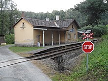
Tomíkovice extends in the west of the Friedeberger Uplands (Žulovská pahorkatina) on the lower reaches of the Skorošický potok before its confluence with the Vidnavka ( Schlippwasser ). The striking Kaní hora ( Hutberg , 476 m) and the Lánský vrch (422 m) rise to the west, while the Borový vrch (487 m) and the Boží hora (527 m) lie to the southeast . The railway line Lipová-lázně - Javorník runs through the Vidnavka valley to the east, and the station in Žlíbek is called Tomíkovice .
Neighboring towns are Annín in the north, Kobylá nad Vidnavkou in the northeast, Žlíbek in the east, Černá Voda in the southeast, Žulová in the south, Skorošice and Petrovice in the southwest, Vojtovice , Sedmlánů and Bergov in the west and Vlčice , Dolní Les and Buková in the northwest.
history
The existence of the village since the time between 1266 and 1268 is documented by its first mention in 1291. The village of Glinna, which was located in the immediate vicinity of Tomíkovice and was probably absorbed into it, has survived from 1284. The village, which belongs to the Principality of Neisse , fell, like others in the area, in the course of the 14th century and was repopulated around 1576 under Bishop Martin von Gerstmann . A Vogtshof was also created. After the end of the Thirty Years' War, Domsdorf's population consisted of 18 farmers and 16 gardeners. Around the mill in the Schlippwasser valley, the small village of Schlippe was established at that time. The Vogtshof received the rights of a manor in 1671 and after numerous changes of ownership it was acquired by the nunnery of St. Maria Magdalena in Neisse in 1733 . After the First Silesian War in 1742 and the partition of Silesia, Domsdorf remained with Austrian Silesia . In 1794 a village school was opened in Domsdorf. The management of the property had become too cumbersome for the monastery, which was now in Prussia , so the sisters sold the Vogtshof in 1807 to Johann Nepomuk Oehl. In 1836 the village consisted of 105 houses and had 604 inhabitants.
In 1844 the yarn dealer Josef Latzel from Gurschdorf bought the farm. At this time, the line weaving and yarn spinning mills in Domsdorf were also in a deep crisis, and the weaver revolt broke out in Prussian Silesia . Latzel founded the first spinning school in Domsdorf in 1848, where the participants were taught more efficient spinning techniques based on Westphalian methods in practical courses, which were then spread throughout the Freiwaldau area.
After the abolition of patrimonial Domsdorf came to the political district Freiwaldau and judicial district Weidenau in 1850 . The inhabitants lived mainly from agriculture. After the downfall of the spinning mill, some of the villagers earned their living as stonemasons and through haulage services in the forest and at the lime works in Setzdorf . At the end of the 19th century, several granite quarries were built in Domsdorf, especially on Hutberg, whereby the stone industry gained little importance compared to Friedeberg . The Vogtsgut with an area of more than 200 hectares was owned by the Latzel family until 1890; after that it was divided. The place was populated by Germans and in 1900 consisted of 108 houses with 642 residents. In the elections to the Czechoslovak parliament in 1929, the communists won the most votes in Domsdorf, and in 1935 the Sudeten German Party became the strongest force. After the Munich Agreement , Gurschdorf was annexed to the German Reich in 1938 and belonged to the Freiwaldau district from 1939 to 1945 . On December 1, 1930 the municipality Domsdorf had 708 inhabitants, on May 17, 1939 749 and on May 22, 1947 there were 349 inhabitants.
After the end of the Second World War, the Germans were expelled and the place was repopulated with Czech populations. In 1949 the property was nationalized. In 1950 there were only 302 residents in the 118 houses in Tomíkovice.
1960 Tomíkovice lost its independence and came as a district to Skorošice . Together with this, it was incorporated into Žulová in 1976 . In the same year the school was also closed. In the 1991 census, Tomíkovice had 55 permanent houses and 233 residents. In 2001 the village consisted of 70 houses in which 246 people lived.
Local division
The district Tomíkovice consists of the basic settlement units Tomíkovice ( cathedral village ) and Žlíbek ( Schlippengrund ).
Personalities
- Ignaz Gulz (1814–1874), doctor, ophthalmologist and first lecturer in otology at the University of Vienna .
- Adolf Latzel , member of the state parliament
Web links
Individual evidence
- ↑ http://www.uir.cz/katastralni-uzemi/748455/Tomikovice
- ↑ http://www.uir.cz/zsj-casti-obce/148458/Cast-obce-Tomikovice
- ↑ Provincial Archives Opava (= Zemský Archiv Opava): Birth register of the parish Gurschdorf 1811–1823. P. 271 - Sign. Vi-V-12
- ↑ Frank Krogmann: Ignaz Gulz - a Viennese ophthalmologist 150 years ago on a study trip through Europe. In: Würzburg medical history reports. 12, 1994, ISSN 0177-5227 , pp. 29-35, especially p. 29.


