
Cradle Mountain Lake St. Clair National Park
| Cradle Mountain Lake St. Clair National Park | |||
|---|---|---|---|
 |
|||
|
|||
| Location: | Tasmania , Australia | ||
| Specialty: | Rainforest | ||
| Next city: | Mole Creek, Tullah | ||
| Surface: | 1,612 km² | ||
| Visitors: | 209,000 (2005) | ||
| Address: |
Cradle Mountain National Park 4057 Cradle Mountain Road Cradle Mountain TAS 7310 |
||
 |
|||

The Cradle Mountain Lake St. Clair National Park (English Cradle Mountain Lake St Clair National Park ) is a national park in the center of the Australian state of Tasmania .
The park has a size of approximately 1612 km² and is part of the Tasmanian Wilderness UNESCO World Heritage Site . The native Austrian Gustav Weindorfer has made a contribution to the preservation of his pristine landscape . Through his efforts, a national park was established on May 16, 1922.
The access from the south is the Lyell Highway over the Derwent Bridge . Access from the north is through the Cradle Valley via Sheffield , Wilmot or Mole Creek .
Landscape image
The national park is located in the central Tasmanian highlands. It contains numerous mountain lakes, waterfalls, gorges, mountain ranges and among others the highest mountain in Tasmania, the 1,617 m high Mount Ossa and the 1216 m high Artillery Knob, which is popular with hikers and mountaineers . In the lower elevations there are larger forests. Four different regions can be distinguished: The Cradle Mountain region with moors, gorges and valleys, the Pelion Range , a plain, the rugged Du Cane Range and finally the Lake St. Clair region, the climax of which is the lake St. Clair is.
Flora
Due to the diversity of the landscape, the vegetation comprises a multifaceted and attractive mosaic of vegetation communities with a span from rainforests to grasslands.
In the Cradle Mountain Region there are moorland and heathland areas that cover large parts of the park.
In the forests, on the other hand, there are ancient plant species whose settlement history can be traced back to Gondwana . These include long-lived conifers such as the sickle-shaped scaly spruce ( Athrotaxis selaginoides ), the cypress-like scaly spruce ( Athrotaxis selaginoides ) and the hybrids of the scaly spruce species Athrotaxis × laxifolia and the Tasmanian leaf disc Phyllocladus aspleniifolius .
Other notable plant species are the cunonia plant Bauera rubioides , the winter ace Tasmannia lanceolata , the shot plant ( Stylidium graminifolium ) and the southern beech ( Nothofagus gunnii and Nothofagus cunninghamii ).
Wildlife
The pouch wolf that was once found in the park area is now extinct. In the national park, however, there are the largest, still living predatory pouches, the marsupial devil , and two slightly smaller predatory pouches, the giant pouch marten and the spotted pouch marten . Other notable animals in the area are the platypus and the short-billed hedgehog .
In addition, following in Tasmania were endemic occurring bird species found in the park: the South Sea warbler species Acanthiza ewingii and Acanthornis magnus, the Tasmanschnäpper , the strong beak Honigschmecker , the yellow cloth - and the Gelbkehl- honeyeater , the Tasman Strangler Crow , the yellow-bellied parrot and the Tasmanian Pfuhl chicken . But you can also meet species imported from Europe such as blackbird , goldfinch and starling .
tourism
The most famous hiking trail in Australia is the 85 km long Overland Track , which connects the Cradle Valley at the north end of the park with Lake St. Clair at the south end. The hiking route leads through the Tasmanian highlands, past Tasmania's highest mountain, Mount Ossa (1617 m) and other impressive mountains such as Cradle Mountain. Depending on the equipment and weather conditions, the track can be tackled in around five to seven days. Since 2005 you have to register for the hiking trail at certain times of the year. There are also numerous shorter hiking trails. There is a visitor center in Cradle Valley that provides information about the area. There are also various camping facilities in the park.
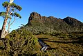
The southern flank of the Acropolis, a rock formation in the park

Plant flowers in the park

Two red-necked wallabies fighting

Dove Lake in the park

Plant fruits in the park
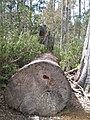
A felled tree in the park

Nose nosed wombat in the national park
.JPG)


See also
Web links
- List of several hikes around Cradle Mountain ( Memento from July 24, 2008 in the Internet Archive )
- Side of the Parks & Wildlife Service Tasmania to Cradle Mountain National Park (English)
- Park & Wildlife Service Tasmania website to Lake St. Clair National Park (English)
- Website of the Parks & Wildlife Service Tasmania on the Overland Track ( Memento from July 20, 2008 in the Internet Archive ) (English)
- Entry on the UNESCO World Heritage Center website ( English and French ).
Individual evidence
- ↑ a b c Otmar Lind & Andrea Niehues: Australia - The most beautiful national parks . Edgar Hoff Verlag, Rappweiler 2007, pp. 287-292
- ↑ Explanations of the National Park Administration on the flora
A Asbestos Range | B Ben Lomond | C Cradle Mountain-Lake St Clair | D Douglas Apsley | F Franklin Gordon Wild Rivers | Freycinet | H Hartz Mountains | K Kent Group | L Lake Pedder | M Maria Island | Mole Creek Karst | Mount Field | Mount William | N Narawntapu | R Rocky Cape | S Savage River | South Bruny | Southwest | Strzelecki | T Tasman | W Walls of Jerusalem