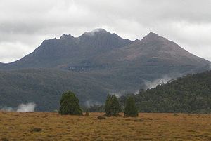
Mount Ossa
| Mount Ossa | ||
|---|---|---|
| height | 1617 m | |
| location | Tasmania | |
| Mountains | Pelion Range | |
| Dominance | 491 km → Mount Wellington ( Victoria ) | |
| Notch height | 1617 m | |
| Coordinates | 41 ° 52 ′ 0 ″ S , 146 ° 2 ′ 0 ″ E | |
|
|
||
| rock | Diabase | |
| Age of the rock | law | |
| particularities | highest mountain in Tasmania | |
The Mount Ossa is in 1,617 meters the highest mountain in Tasmania .
Mount Ossa is located in the center of the Australian state of Tasmania in the Cradle Mountain Lake St. Clair National Park . The national park has a size of about 1,612 km² and is part of the UNESCO World Heritage of Humanity. The mountain is relatively easy to climb, there are only rocks to conquer directly at the summit. The weather on the mountain is very changeable, in winter it is often icy and cold with stormy winds and snowfall. Snow is mostly from May to October, but even in the summer months the summit is sometimes white. The summer months are still the best time to climb as the conditions are less extreme. The region owes its untouched beauty to the native Austrian Gustav Weindorfer . Through his efforts, a national park was established on May 16, 1922.
Web links
- Mount Ossa, Tasmania on Peakbagger.com (English)


