GR 10
| GR 10 | |
|---|---|
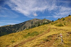
 GR 10 at Col de la Cirere |
|
| Data | |
| length | 866 km |
| location | Pyrenees , France |
| Starting point |
Hendaye 43 ° 21 '33.1 " N , 1 ° 45' 58.2" W. |
| Target point |
Banyuls-sur-Mer 42 ° 28 ′ 56.5 " N , 3 ° 7 ′ 43.6" E |
| Type | Long-distance hiking trail |
| season | summer |
| Months | June to October |
The GR 10 (French Grande Randonnée 10 ) is a French GR long-distance hiking trail that crosses the Pyrenees from the Atlantic to the Mediterranean and the like. a. crossed through the Pyrenees National Park .
The 866 km long and 48,000 meters high long-distance hiking trail connects Hendaye with Banyuls-sur-Mer and runs north of the French - Spanish border through the departments Pyrénées-Atlantiques , Hautes-Pyrénées , Haute-Garonne , Ariège and Pyrénées-Orientales . On the Spanish side, there is a parallel hiking trail, the GR 11 . Between these two paths is the Haute randonnée pyrénéenne , which crosses the border and follows the main ridge of the Pyrenees.
Experienced hikers need one and a half to two months for the route.
Web links
Commons : GR 10 - collection of images, videos and audio files
- www.gr10.fr Website of the Les Amis GRdistes association
- Étapes du GR 10 on Claude Azémard's website
- The Pyrenean Way , Steve Cracknell's information page
- GR10 Pyrenees Walk , information site in English
- About the Pyrenees on the GR 10 , blog by Sascha Radloff
- Randonnée avec le GR10 à travers les Pyrénées-Atlantiques , French and English-language information site with a downloadable track of the GR10
- Gites d'étape et Refuges , French-language information site with accommodations on the GR10 with distances and walking times
- Across the Way of St. James: Godless pilgrimage through the Pyrenees , article by Ulrike Koltermann in Spiegel Online , May 11, 2012