
Gaisbergferner
| Gaisbergferner | ||
|---|---|---|
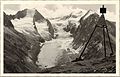
 Gaisbergferner (2005) |
||
| location | Tyrol , Austria | |
| Mountains | Ötztal Alps , Gurgler Kamm | |
| Type | Valley glacier | |
| length | 2.5 km (2009) | |
| surface | 1.03 km² (2006) | |
| Exposure | northwest | |
| Altitude range | 3390 m above sea level A. - 2460 m above sea level A. | |
| Coordinates | 46 ° 49 '36 " N , 11 ° 4' 9" E | |
|
||
| drainage | Gaisbergbach → Gurgler Ache → Ötztaler Ache → Inn | |

The Gaisbergferner , also called Gaißbergferner , is a valley glacier that is 450 meters wide at its widest and 2.5 km long in 2009 , southeast of Obergurgl in the Ötztal Alps in the Austrian state of Tyrol . It flows from the main Alpine ridge in a north-westerly direction through the Gaisberg valley . Its nutrient area is on the Gaisbergjoch at an altitude of 3237 meters. The yoke lies between the Hohen First ( 3403 m ) in the north and the 3302 meter high Seewerspitze in the south. The way to climb these mountains leads over the glacier and the yoke.
decline
In the Little Ice Age , a cold period that lasted into the early 19th century, the Gaisbergferner was still around 3.8 km long, but it is retreating due to global warming . In 2005, this glacier melt caused the glacier tongue to shrink by 70 meters.
The Gaisbergferner around 1956

The Gaisbergferner 2016


Card and individual evidence
- Alpine Club Map 1: 25,000, sheet 30/1, Gurgl
- ↑ a b c Gaisbergferner (Tyrol). www.swisseduc.ch, accessed on August 31, 2009 .
- ^ J. Abermann et al .: Quantifying changes and trends in glacier area and volume in the Austrian Ötztal Alps (1969-1997-2006). In: The Cryosphere . Volume 3, 2009, pp. 205–215 ( online )
- ↑ Alpine Club Card 30/1 Ötztal Alps, Gurgl, 2000
- ↑ Dramatic glacier retreat - glacier report of the Alpine Club 2005/06. Austrian Alpine Association, quoted from APA , accessed on August 31, 2008 .