Galgenkopf (Thuringian Forest)
| Gallows head | ||
|---|---|---|
|
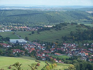
The gallows head separates the villages of Schmerbach (front) and Schwarzhausen (back); behind the Grübelsberg |
||
| height | 426 m above sea level NHN | |
| location | near Schwarzhausen ; District of Gotha , Thuringia ( Germany ) | |
| Mountains | Thuringian Forest | |
| Coordinates | 50 ° 53 '57 " N , 10 ° 27' 33" E | |
|
|
||
| rock | Red sandstone | |
The Galgenkopf in the Thuringian Forest is 426 m above sea level. NHN high mountain in the area of the city of Waltershausen in the Thuringian district of Gotha .
Geographical location
The Galgenkopf rises in the Thuringian Forest Nature Park between the districts of Schmerbach in the west and Schwarzhausen in the east. It forms the southern boundary of the Schmerlingsbach, which flows immediately to the north outside the nature park and flows into the Emse as a left tributary near Schwarzhausen . To the south the landscape leads over to the Waltershausen district of Winterstein, a little further up on the Emse . Parts of the Thuringian Forest conservation area ( CDDA no. 20896; designated in 1963; 1,443.4212 km² ) are located on the mountain .
Field name and place of execution
The field name Galgenkopf refers to a late medieval place of execution for the Lords of Wangenheim-Winterstein , who had their seat in the neighboring Winterstein Castle. The summit plateau has another field name: pleasure . The local history interprets this place as a meeting place for the spectators at the execution of sentences. The hanging of criminals, often staged as popular amusement, was also widespread in Thuringia. Another place of jurisdiction - also with a gallows - was created on the Seebach border (field name Am Goldberg ) when the jurisdiction of the place Schmerbach was also granted to the Lord von Ütterodt in Schmerbach.
Agriculture
The gallows head still shows a pronounced structure of medieval agricultural terraces on its slopes. The fields laid out in horizontal strips are now used as pasture for cattle. The open country character is endangered by increasing bush cover. On the western and southern slopes of the mountain, fruit trees were planted on a trial basis as early as the 19th century.
Individual evidence
- ↑ a b c Map services of the Federal Agency for Nature Conservation ( information )
- ↑ Official topographic maps of Thuringia 1: 10,000. Wartburgkreis, district of Gotha, district-free city of Eisenach . In: Thuringian Land Survey Office (Hrsg.): CD-ROM series Top10 . CD 2. Erfurt 1999.
- ↑ Winterstein municipality (ed.): Winterstein. Pictures stories and history . Löhr printing works, Ruhla 1996, From the saga treasure, p. 14-15 .

