Grübelsberg (Thuringian Forest)
| Grübelsberg | ||
|---|---|---|
|
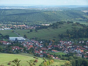
Schmerbach (front) and Schwarzhausen, behind the wooded Grübelsberg (upper half of the picture) |
||
| height | 443.7 m above sea level NN | |
| location | Thuringia ( Germany ) | |
| Mountains | Thuringian Forest | |
| Coordinates | 50 ° 53 '44 " N , 10 ° 29' 42" E | |
|
|
||
| rock | Red sandstone | |
The Grübelsberg is 443.7 m above sea level. NN m high mountain near Waltershausen , it marks the border between the district of Gotha and the Wartburg district in Thuringia .
The Grübelsberg is an elevation about 2.5 km long and a maximum of 600 m wide, it also marks the southeasternmost point of the municipality of Hörselberg-Hainich , and is for the most part in the corridor of the Sondra district . The neighboring towns of Langenhain (a district of Walterhausen), Bad Tabarz and Waltershausen with the districts of Fischbach and Schwarzhausen also have some parcels on the Grübelsberg.
The mountain had been cleared since the Middle Ages, and two deserted areas were in the immediate vicinity. The mountain is used for agriculture on the east side, the west side has been forested for centuries and belonged to the Wangenheim forest property. In the north, the mountain merges imperceptibly into the Dachsberg , which is also divided between the districts. On the south side of the Grübelsberg, the federal road 88 runs to Friedrichroda .
Individual evidence
- ↑ Official topographic maps of Thuringia 1: 10,000. Wartburgkreis, district of Gotha, district-free city of Eisenach . In: Thuringian Land Survey Office (Hrsg.): CD-ROM series Top10 . CD 2. Erfurt 1999.

