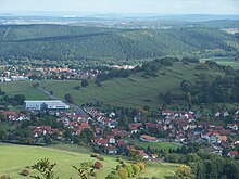
Schmerbach (Waltershausen)
|
Schmerbach
City of Waltershausen
Coordinates: 50 ° 54 ′ 0 ″ N , 10 ° 26 ′ 59 ″ E
|
|
|---|---|
| Height : | 358 m |
| Incorporation : | January 1, 1996 |
| Incorporated into: | Emsetal |
| Postal code : | 99880 |
| Area code : | 036259 |
|
Location of Schmerbach in Waltershausen
|
|
|
Half-timbered house in Schmerbach
|
|
Schmerbach is a district of the town of Waltershausen in the Gotha district in Thuringia .
geography
Schmerbach is located on the northern edge of the Thuringian Forest at an altitude of around 360 to 385 meters in a valley basin at the foot of the Großer Inselsberg . The "Schmerbach", which is incorrectly called "Schmerlingsbach" and flows into the Emse in the neighboring town of Schwarzhausen, meanders through the location . In the east of the village the " Galgenkopf " rises 426 m above sea level. NN, in the west is the 567.7 m above sea level. NN high "Great Wartberg" and in the north the 481.8 m above sea level. NN high "Reitzenberg" the northern boundary of the municipality. The B 88 runs through the village and connects it with Seebach and Wutha-Farnroda in the west and with Waltershausen in the east. Via Wintersteiner Strasse and Lerchenbergstrasse , the place is on a direct route over the eastern flank of the south to 450.1 m above sea level. NN uplifting "Lerchenbergs" associated with Winterstein . The road leads directly past a 5.3 hectare allotment garden .
history
Schmerbach was first mentioned in a document around 1350/60. The place name comes from the "Schmerbach" leading through the place (smer = greasy, smeary; based on the ground). The brook name "Schmerlingsbach" is wrongly used, an idea of the priest Dr. Berbig, but has no historical or etymological background. The place on the historic wine route through the Thuringian Forest was owned by the Lords of Wangenheim and came into the possession of the Lords of Uetterodt , who owned a castle in Thal , in 1458 (until 1837) along with other places . In addition to forestry and agriculture as well as line weaving, haulage in particular had great economic importance in the area in earlier times. In addition, copper mining and charcoal burning were carried out in the area. Weaving and carting experienced a decline at the beginning of the 19th century, after which many residents found a poor livelihood in button production and collecting forest fruits. A metal goods factory was established around 1900. In 1996, Schmerbach merged with three surrounding communities and became part of the Emsetal community . The village has belonged to the town of Waltershausen since December 31, 2013, because the unified municipality of Emsetal had to be incorporated into the town due to its low population.
Christ Church
Schmerbach belonged to the church in Schwarzhausen, and the children went to school here. After 1740 the place got its own school, to which the first teacher was appointed in 1756. In 1824 it was decided to build a church. The Christ Church was completed and inaugurated on July 6, 1851 after donations in money and in kind from the residents, the duchy and the evangelical Gustav-Adolf-Werk . Presumably a few years later the church received a Knauf organ . The neo-Romanesque church has the size of 10 by 17 meters and is a plastered half-timbered building. The tower is drawn in on the short-sided west facade. It is completely slated, including the roof. The top of the tower is octagonal and does not have a dome, but only a tower ball with a weather vane attached . The interior is illuminated through five high windows on either side of the nave. The interior, with a flat ceiling depicting a stylized starry sky, shows double galleries and a pulpit altar from 1851. After a renovation in 1895, the last painting was done in the early 1990s. Even today the community belongs to the parish of Schwarzhausen.
Culture
Events
- Fountain festival on Pentecost Sunday: commemorates the replacement of the wooden troughs on the public fountain for stone ones in 1861.
- Koehler Festival in the first week of July: reminds us of the charcoal trade that was once important for the village
Worth seeing
- Christ Church
- Village street with a fountain
- Wintersteiner Straße with the village pond and Platz unter den Linden (traffic-calmed area)
Partner communities
literature
- Horst H. Müller: Travel Guide Thuringian Forest and Peripheral Regions , (1977) p. 600 ff. (1989: ISBN 978-3-350-00263-4 )
- Ellrich / Heinke / Hoerenz: Between Hörsel and Wilder Gera , Weimar 2005, ISBN 3-86160-167-2
Individual evidence
- ↑ a b c Reißig, Dagmar; Explanations of the local history on the occasion of the 666 anniversary in 2016
- ↑ Confirmation from the state parliament
- ^ City of Waltershausen :: City administration / Citizens' Service :: Sister cities. In: City of Waltershausen - waltershausen.de. City administration Waltershausen, accessed on December 23, 2018 .


