
Emsetal
Emsetal was a unified municipality in the Thuringian Forest , it is located on the Großer Inselsberg and belongs to the Thuringian district of Gotha . From 1996 to 2013 it consisted of the previously independent towns of Fischbach, Schmerbach, Schwarzhausen and Winterstein, which now belong to the town of Waltershausen .
geography

location
The municipality of Emsetal was located on the western edge of the Gotha district, about 18 kilometers (as the crow flies) from the district town of Gotha . The sub-towns of Emsetal were at the foot of the Großer Inselsberg and its foothills. Neighboring communities were the town of Waltershausen and Tabarz in the Gotha district and Bad Liebenstein ( Steinbach district ), Ruhla , Seebach and Hörselberg-Hainich in the Wartburg district .
Mountains and rivers
The southern part of the municipality was completely forested and extended to the ridge of the Thuringian Forest with the Rennsteig . The north-western border point on the Großer Inselsberg ( 914.2 m above sea level ) was considered the highest point . The mountains and elevations were also remarkable: Upper Beerberg ( 831.1 m above sea level ), Drehberg ( 754.3 m above sea level ), Great Weissenberg ( 746.7 m above sea level ), Little Weissenberg ( 724.5 m) above sea level ), Kleiner Inselsberg ( 705.6 m above sea level ), Hübelskopf ( 694.6 m above sea level ), Breitenberg ( 634.1 m above sea level ), Thielberg ( 565.3 m above sea level ), Reitzenberg ( 481.8 m above sea level ), Grübelsberg ( 443.7 m above sea level ), Galgenkopf ( 425.8 m above sea level ) and Sandberg ( 415.5 m above sea level ). The northern part of the municipality has been used for agriculture since the Middle Ages, with grazing dominating. The lowest point was on the Emse in Kaisergrund ( 305 m above sea level ). The municipal area was drained by the Emse , an orographically left tributary of the Hörsel . The Fischbach and the Schmerbach flow into the Emse as main tributaries.
Community structure

Emsetal consisted of the districts Fischbach , Schmerbach , Schwarzhausen and Winterstein .
history
The unified community of Emsetal was created in 1996 through the merger of the previously independent communities Fischbach , Schmerbach , Schwarzhausen and Winterstein . The name of the community refers to the river Emse .
The district of Schwarzhausen is rated as the starting point for the settlement history of the upper Ems Valley. The place was mentioned for the first time in 787 and was connected to the Rennsteig and the places south of the forest via Schweinaer Straße . In the north and east, paths and roads into the fertile Thuringian basin were used as old settlements. Barely five kilometers north is the legendary Great Hörselberg with the Venus Cave, which was important in early history .
Castles were built to control the old roads and the first settlements - for this purpose, the Scharfenburg near Thal was built first. The later territorial development of the Landgraviate of Thuringia brought about the construction of further fortifications. During this time the Winterstein Castle was built and only a few hundred meters away the smaller Sommerstein Castle complex , which is still present today with the remains of a moat as a ground monument. The lords of Wangenheim and the lords of Uetterodt were the dominant families in the districts for centuries.
Archaeological finds on the Rennsteig and in the vicinity of the places show the beginning of the search for and use of ore deposits - copper smelting is documented in writing. Forest farmers and charcoal burners probably made up the greater part of the village population.
The municipality of Emsetal was incorporated into the city of Waltershausen on December 31, 2013.
politics
Last municipal council
The local election on June 7, 2009 resulted in the same distribution of the 16 seats in the local council as the previous local election in 2004:
- CDU : 10 seats
- FWG Emsetal : 4 seats
- FDP : 2 seats
Last mayor
The honorary mayor Klaus Reissig was elected on March 10, 2002.
Incorporation
The municipality of Emsetal was incorporated into Waltershausen on December 31, 2013. Both mayors signed a corresponding contract on January 29, 2013.
Culture and sights
tourism
- Due to their proximity to the neighboring health resorts of Tabarz, Friedrichroda and Brotterode, the districts had a long tradition as winter sports and tourist resorts, which also enriched cultural life. The Bergbühne Fischbach was built on the southern outskirts of Fischbach in 1953 and played in the summer season in cooperation with the Eisenach State Theater . This place has also hosted concerts and folklore events.
- The Große Inselsberg and the Rennsteig belonged to the municipality and were the most famous sights.
Buildings
- The ruins of Winterstein Castle were in Winterstein , and the Wangenheim hereditary burial , the memorial for Stutzel and the home parlor were also worth seeing .
- A sight on the Rennsteig in the Wintersteiner district is the Ruhla ski hut with the bird of prey enclosure created there.
- The former Wangenheim Castle in Fischbach was built in stages from 1587 to 1639, until December 31, 2013 it housed the municipal administration and a home parlor. Gravestones of this noble family were in the Jacobuskirche in the locality of Fischbach.
- There was another palace complex in Schwarzhausen - it was built by the Lords of Uetterodt and is now used as a school.
- In the district of Schmerbach there were numerous historical running fountains.

Fischbach Castle

Schwarzhausen Castle

Winterstein Castle

Fischbach mountain stage
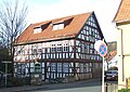
Half-timbered house in Schmerbach

Hotel at the Ruhla ski hut


Cultural associations
- The charcoal burner association also contributed to the cultural life of Schmerbach. The Koehler Festival was celebrated every year in a forest north of the village.
- In all parts of the village, cultural events were offered as song and folk evenings to support the tourism projects . The local history and local history associations enabled the establishment of local parlors in Winterstein and Fischbach. An extensive network of hiking trails opened up the natural beauties of the districts.
sports clubs
- After the First World War , winter sports began to develop in the Thuringian Forest. The Ruhlaer Skihütte was built on the Rennsteig on the initiative of skiers from Ruhla and Eisenach and became the first center for winter sports enthusiasts in the region. In addition to cross-country skiing and tobogganing, ski jumping has also been in demand since the 1920s, ski jumps were built at Fischbach and Winterstein, and for economic reasons only the jumps at Brotterode, Tabarz and Ruhla were used.
- The annual Rennsteiglauf was of great importance for sport, and sports fans from the Emsetal also participated in the organizational preparation.
The SV Emsetal eV was the largest association of the unified community Emsetal and was founded on May 6, 1999. Its predecessors are the SV unit Schmerbach / Schwarzhausen and the soccer department of SV Winterstein 90 eV
Motorsport
The district of Winterstein was the starting point for the ADAC Rennsteig hill climb, which was held annually from 2005 to 2009 . The 4,100 m long race track, from Winterstein on the L 1027 in the direction of Bad Liebenstein up to the Rennsteig , was located exactly on the opposite side of the mountain from the legendary Glasbach race . A special feature was the division of the paddock : the touring cars were down in the village up to and including 2008; the racing cars up in the finish area.
Individual evidence
- ↑ Official topographic maps of Thuringia 1: 10,000. Wartburgkreis, district of Gotha, district-free city of Eisenach . In: Thuringian Land Survey Office (Hrsg.): CD-ROM series Top10 . CD 2. Erfurt 1999.
- ↑ Katja Vogel, Thomas Huck: History of the Gothaer Land. Exhibition guide . Ed .: Gothaer Museum for Regional History. 1997, ISSN 0863-2421 . (as digitized version) ( Memento from July 19, 2011 in the Internet Archive ) (PDF; 2.8 MB)
- ↑ Horst H. Müller: "Travel Guide Thuringian Forest and Edge Areas" (1977) p. 739 ff.
- ↑ StBA: Area changes from January 1st to December 31st, 2013
- ↑ http://www.wahlen.thueringen.de/datenbank/wahl1/wahl.asp?wahlart=GW&wjahr=2009&habenErg=GEM&wknr=067&gemnr=67084
- ↑ http://www.wahlen.thueringen.de/datenbank/wahl1/wahl.asp?wahlart=GW&wjahr=2004&habenErg=GEM&wknr=067&gemnr=67084
- ↑ Local elections 2006. Final results. Elections for district administrators, mayors and mayors. (PDF; 2.4 MB) The State Returning Officer, archived from the original on December 16, 2013 ; Retrieved March 6, 2010 .
- ↑ Thüringer Allgemeine: Integration contract for Emsetal has been signed
- ↑ http://www.rennsteig-bergrennen.de/2009/ausschreibung09.pdf